
Make a donation
Gear up for your next adventure:
As an Amazon Associate, this site earns from qualifying purchases at no extra cost to you.
Lincolnshire Wolds National Landscape topographic map
Click on the map to display elevation.
Gear up for your next adventure:
As an Amazon Associate, this site earns from qualifying purchases at no extra cost to you.
About this map
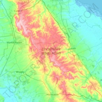
Name: Lincolnshire Wolds National Landscape topographic map, elevation, terrain.
Average elevation: 48 m
Minimum elevation: -1 m
Maximum elevation: 170 m
Lincolnshire trails, hiking, mountain biking, running and outdoor activities
Make a donation
Gear up for your next adventure:
As an Amazon Associate, this site earns from qualifying purchases at no extra cost to you.
Other topographic maps
Click on a map to view its topography, its elevation and its terrain.
Limber Hill
United Kingdom > England > Lincolnshire > West Lindsey > Great Limber CP
Average elevation: 45 m
Make a donation
Gear up for your next adventure:
As an Amazon Associate, this site earns from qualifying purchases at no extra cost to you.
Moor Barn
United Kingdom > England > Lincolnshire > South Kesteven > Hough-on-the-Hill
Average elevation: 31 m
Make a donation
Gear up for your next adventure:
As an Amazon Associate, this site earns from qualifying purchases at no extra cost to you.
Make a donation
Gear up for your next adventure:
As an Amazon Associate, this site earns from qualifying purchases at no extra cost to you.
Make a donation
Gear up for your next adventure:
As an Amazon Associate, this site earns from qualifying purchases at no extra cost to you.
Make a donation
Gear up for your next adventure:
As an Amazon Associate, this site earns from qualifying purchases at no extra cost to you.
Uffington Park
United Kingdom > England > Lincolnshire > South Kesteven > Uffington
Average elevation: 30 m
Bowser's Corner
United Kingdom > England > Lincolnshire > East Lindsey > New Leake
Average elevation: 1 m
Make a donation
Gear up for your next adventure:
As an Amazon Associate, this site earns from qualifying purchases at no extra cost to you.
Make a donation
Gear up for your next adventure:
As an Amazon Associate, this site earns from qualifying purchases at no extra cost to you.
Holbeach Marsh
United Kingdom > England > Lincolnshire > South Holland > Holbeach CP > Holbeach St Marks
Average elevation: 4 m
Make a donation
Gear up for your next adventure:
As an Amazon Associate, this site earns from qualifying purchases at no extra cost to you.
Welton Cliff
United Kingdom > England > Lincolnshire > West Lindsey > Welton CP
Average elevation: 53 m
Make a donation
Gear up for your next adventure:
As an Amazon Associate, this site earns from qualifying purchases at no extra cost to you.
Three Kings Deer
United Kingdom > England > Lincolnshire > North Kesteven > Threekingham
Average elevation: 24 m
Make a donation
Gear up for your next adventure:
As an Amazon Associate, this site earns from qualifying purchases at no extra cost to you.
Belleau Bridge
United Kingdom > England > Lincolnshire > East Lindsey > Aby > Belleau
Average elevation: 30 m
Make a donation
Gear up for your next adventure:
As an Amazon Associate, this site earns from qualifying purchases at no extra cost to you.
Make a donation
Gear up for your next adventure:
As an Amazon Associate, this site earns from qualifying purchases at no extra cost to you.
Make a donation
Gear up for your next adventure:
As an Amazon Associate, this site earns from qualifying purchases at no extra cost to you.
Holbeach Clough
United Kingdom > England > Lincolnshire > South Holland > Holbeach CP > Saracen's Head
Average elevation: 4 m
Make a donation
Gear up for your next adventure:
As an Amazon Associate, this site earns from qualifying purchases at no extra cost to you.
Make a donation
Gear up for your next adventure:
As an Amazon Associate, this site earns from qualifying purchases at no extra cost to you.
Scottlethorpe
United Kingdom > England > Lincolnshire > South Kesteven > Edenham
Average elevation: 49 m
Make a donation
Gear up for your next adventure:
As an Amazon Associate, this site earns from qualifying purchases at no extra cost to you.
Louth Navigation
United Kingdom > England > Lincolnshire > East Lindsey > Alvingham
Average elevation: 8 m
Caen Hill
United Kingdom > England > Lincolnshire > West Lindsey > Great Limber CP
Average elevation: 83 m
Make a donation
Gear up for your next adventure:
As an Amazon Associate, this site earns from qualifying purchases at no extra cost to you.
Make a donation
Gear up for your next adventure:
As an Amazon Associate, this site earns from qualifying purchases at no extra cost to you.
Make a donation
Gear up for your next adventure:
As an Amazon Associate, this site earns from qualifying purchases at no extra cost to you.
Make a donation
Gear up for your next adventure:
As an Amazon Associate, this site earns from qualifying purchases at no extra cost to you.