
Annapurna I topographic map
Interactive map
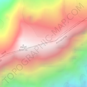
Click on the map to display elevation.
About this map
Name: Annapurna I topographic map, elevation, terrain.
Average elevation: 7,127 m
Minimum elevation: 5,715 m
Maximum elevation: 8,033 m
The mountain is named after Annapurna, the Hindu goddess of food and nourishment, who is said to reside there. The name Annapurna is derived from the Sanskrit-language words purna ("filled") and anna ("food"), and can be translated as "everlasting food".[7] Many streams descending from the slopes of the Annapurna Massif provide water for the agricultural fields and pastures located at lower elevations.[8]
Other topographic maps
Click on a map to view its topography, its elevation and its terrain.