
Make a donation
Gear up for your next adventure:
As an Amazon Associate, this site earns from qualifying purchases at no extra cost to you.
Aegean topographic map
Click on the map to display elevation.
Make a donation
Gear up for your next adventure:
As an Amazon Associate, this site earns from qualifying purchases at no extra cost to you.
About this map
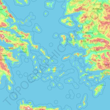
Name: Aegean topographic map, elevation, terrain.
Location: Aegean, Greece (35.25797 24.04098 40.11242 29.68381)
Average elevation: 123 m
Minimum elevation: -2 m
Maximum elevation: 2,615 m
Make a donation
Gear up for your next adventure:
As an Amazon Associate, this site earns from qualifying purchases at no extra cost to you.
Other topographic maps
Click on a map to view its topography, its elevation and its terrain.
Athens
Greece > Attica > Regional Unit of Central Athens
Owing to the rain shadow of the Pindus Mountains, annual precipitation of Athens is lower than most other parts of Greece, especially western Greece. As an example, Ioannina receives around 1,300 mm (51 in) per year, and Agrinio around 800 mm (31 in) per year. Daily average highs for July have been measured…
Average elevation: 168 m
Make a donation
Gear up for your next adventure:
As an Amazon Associate, this site earns from qualifying purchases at no extra cost to you.
Paradeisos
Greece > Peloponnese Region > Corinthia Regional Unit > Municipal Unit of Loutraki - Perachora
Average elevation: 60 m
Aposelemi
Greece > Region of Crete > Heraklion Regional Unit > Asterousia Municipal Unit
Average elevation: 335 m
Make a donation
Gear up for your next adventure:
As an Amazon Associate, this site earns from qualifying purchases at no extra cost to you.
Eleusis
Greece > Attica > Regional Unit of West Attica > Municipal Unit of Elefsina
Average elevation: 30 m
Rapsani
Greece > Thessaly > Larisa Regional Unit > Municipal Unit of Kato Olympos
Rapsani is sited at an altitude of 600 meters. The location of Peneus river at the level of the station Rapsani is a scenic landscape. The town is close (5 km) from a station that bears the same name.
Average elevation: 501 m
Karpenisi
Greece > Central Greece > Regional Unit of Evrytania > Municipal Unit of Karpenisi
Karpenisi (Greek: Καρπενήσι, Greek pronunciation: [karpeˈnisi]) is a town in central Greece. It is the capital of the regional unit of Evrytania. Karpenisi lies within the valley of the river Karpenisiotis (Καρπενησιώτης), a tributary of the Megdovas, in the southern part of the Pindus…
Average elevation: 1,236 m
Tefeli
Greece > Region of Crete > Heraklion Regional Unit > Asterousia Municipal Unit
Average elevation: 350 m
Make a donation
Gear up for your next adventure:
As an Amazon Associate, this site earns from qualifying purchases at no extra cost to you.
Athens
Greece > Attica > Regional Unit of Central Athens
Owing to the rain shadow of the Pindus Mountains, annual precipitation of Athens is lower than most other parts of Greece, especially western Greece. As an example, Ioannina receives around 1,300 mm (51 in) per year, and Agrinio around 800 mm (31 in) per year. Daily average highs for July have been measured…
Average elevation: 168 m
Σέρβια
Greece > Epirus and Western Macedonia > Kozani Regional Unit > Servia Municipal Unit
The Philharmonic band of the town, established in 1928, is run by the "Morphotikos Omilos Servion", which is the main Cultural Society of the town. It organises a wide range of cultural events and supports teaching classes for children and adults in painting, dance, choir, and chess. Hang gliding is prominent…
Average elevation: 565 m
Demati
Greece > Region of Crete > Heraklion Regional Unit > Arkalochori Municipal Unit
Average elevation: 274 m
Make a donation
Gear up for your next adventure:
As an Amazon Associate, this site earns from qualifying purchases at no extra cost to you.
Tripoli
Greece > Peloponnese Region > Arcadia Regional Unit
The city of Tripoli has a hot-summer Mediterranean climate (Köppen: Csa). Ιt is located in the center of the Peloponnese, at the western border of a large basin (a polje at about 650 m in altitude, a length of ca. 30 km and a width between 12,5 and 2,5 km). The city is today the capital of the regional unit…
Average elevation: 873 m
Αγία Παρασκευή
Greece > Central Macedonia > Chalkidiki Regional Unit > Pallini Municipal Unit
Average elevation: 165 m
Make a donation
Gear up for your next adventure:
As an Amazon Associate, this site earns from qualifying purchases at no extra cost to you.
Labyrintaki Cave
Greece > Region of Crete > Heraklion Regional Unit > Mires Municipal Unit
Average elevation: 308 m
Make a donation
Gear up for your next adventure:
As an Amazon Associate, this site earns from qualifying purchases at no extra cost to you.
Make a donation
Gear up for your next adventure:
As an Amazon Associate, this site earns from qualifying purchases at no extra cost to you.
Doxato
Greece > Eastern Macedonia and Thrace > Drama Regional Unit > Doxato Municipal Unit
Average elevation: 114 m
Kalo Chorio
Greece > Region of Crete > Heraklion Regional Unit > Gouves Municipal Unit
Average elevation: 269 m
Parisata
Greece > Ioanian Islands > Kefallonia Regional Unit > Paliki Municipal Unit > Monopolata
Average elevation: 249 m
Make a donation
Gear up for your next adventure:
As an Amazon Associate, this site earns from qualifying purchases at no extra cost to you.
Make a donation
Gear up for your next adventure:
As an Amazon Associate, this site earns from qualifying purchases at no extra cost to you.
Συκή
Greece > Thessaly > Regional Unit of Magnesia > Municipal Unit of Afetes
Average elevation: 220 m
Eleusis
Greece > Attica > Regional Unit of West Attica > Municipal Unit of Elefsina
Average elevation: 30 m
Malia
Greece > Region of Crete > Heraklion Regional Unit > Malia Municipal Unit
Average elevation: 199 m
Make a donation
Gear up for your next adventure:
As an Amazon Associate, this site earns from qualifying purchases at no extra cost to you.
Klima
Greece > Region of Crete > Heraklion Regional Unit > Tybakio Municipal Unit
Average elevation: 176 m
Patras
Greece > Western Greece > Achaia Regional Unit
A central feature of the urban geography of Patras is its division into upper and lower sections. This is the result of an interplay between natural geography and human settlement patterns; the lower section of the city (Kato Poli), which includes the 19th-century urban core and the port, is adjacent to the…
Average elevation: 283 m
Make a donation
Gear up for your next adventure:
As an Amazon Associate, this site earns from qualifying purchases at no extra cost to you.
Make a donation
Gear up for your next adventure:
As an Amazon Associate, this site earns from qualifying purchases at no extra cost to you.
Περτούλι
Greece > Thessaly > Trikala Regional Unit
Pertouli is a small mountain village within the province of Trikala in Greece and is situated at an altitude of 1,150 metres on the central part of the Pindos mountain range.
Average elevation: 1,358 m
Make a donation
Gear up for your next adventure:
As an Amazon Associate, this site earns from qualifying purchases at no extra cost to you.
Argos
Greece > Peloponnese, Western Greece and the Ionian > Argolis Regional Unit
Average elevation: 322 m
Vergina
Greece > Central Macedonia > Imathia Regional Unit > Veria Municipality
Average elevation: 141 m
Charakas
Greece > Region of Crete > Heraklion Regional Unit > Asterousia Municipal Unit
The community of Charakas (Δημοτική Κοινότητα Χάρακος) consists of the village Charakas and the smaller villages Agia Fotia (Αγιά Φωτιά) (pop. 22, at elevation 275 m, 2 km to the West from Charakas) and Doraki (Δωράκι) (pop. 24, at elevation 310 m, 1.5 km to the East from Charakas).
Average elevation: 357 m
Make a donation
Gear up for your next adventure:
As an Amazon Associate, this site earns from qualifying purchases at no extra cost to you.
Make a donation
Gear up for your next adventure:
As an Amazon Associate, this site earns from qualifying purchases at no extra cost to you.
Αβία
Greece > Peloponnese Region > Messenia Regional Unit > Municipal Unit of Avia
Average elevation: 45 m
Makrichori
Greece > Thessaly > Larisa Regional Unit > Municipal Unit of Makrichori
Average elevation: 139 m
Make a donation
Gear up for your next adventure:
As an Amazon Associate, this site earns from qualifying purchases at no extra cost to you.
Souli
Greece > Peloponnese Region > Arcadia Regional Unit > Municipal Unit of Megalopoli
Souli (Greek: Σούλι) is a village and a community in the municipality of Megalopoli in southwestern Arcadia, Greece. The community consists of the mountain villages Souli and Derveni. Both villages are located in the mountains on the border with Messenia, at about 500 m elevation. Derveni is on the old…
Average elevation: 569 m
Kampos Marathokampou
Greece > Northern Aegean > Samos Regional Unit > Municipal Unit of Marathokabos
Average elevation: 99 m
Περτούλι
Greece > Thessaly > Trikala Regional Unit
Pertouli is a small mountain village within the province of Trikala in Greece and is situated at an altitude of 1,150 metres on the central part of the Pindos mountain range.
Average elevation: 1,358 m
Vikos–Aoos National Park
Greece > Epirus > Ioannina Regional Unit
The Vikos–Aoös National Park (Greek: Εθνικός Δρυμός Βίκου–Αώου, romanized: Ethnikós Drymós Víkou–Aóou) is a national park in the region of Epirus in northwestern Greece. The park, founded in 1973, is one of ten national parks in mainland Greece and is located 30 kilometres (19…
Average elevation: 1,147 m
Make a donation
Gear up for your next adventure:
As an Amazon Associate, this site earns from qualifying purchases at no extra cost to you.
Vergina
Greece > Central Macedonia > Imathia Regional Unit > Veria Municipality
Average elevation: 141 m
Pinios
Greece > Western Greece > Elis Regional Unit > Municipal Unit of Lassion > Αντρώνι
Average elevation: 558 m
Sindos
Greece > Central Macedonia > Thessaloniki Regional Unit > Municipal Unit of Echedoros
Average elevation: 7 m
Kavala
Greece > Eastern Macedonia and Thrace > Kavala Regional Unit
On July 16, 2022, Meridian Flight 3032 crashed nearby. The Ukrainian-registered Antonov An-12BK was carrying 11.5 tons of ammunition from Niš to Dhaka when the plane began to lose altitude over the Aegean and turned around, but went down 35 kilometers west of Kavala Airport. All 8 crew members were killed.
Average elevation: 173 m
Make a donation
Gear up for your next adventure:
As an Amazon Associate, this site earns from qualifying purchases at no extra cost to you.
Λαγονήσι
Greece > Attica > Regional Unit of East Attica > Kalyvia Thorikou Municipal Unit
Average elevation: 30 m
Make a donation
Gear up for your next adventure:
As an Amazon Associate, this site earns from qualifying purchases at no extra cost to you.
Tsivili beach
Greece > Ioanian Islands > Zakynthos Regional Unit > Arkadii Municipal Unit
Average elevation: 15 m
Make a donation
Gear up for your next adventure:
As an Amazon Associate, this site earns from qualifying purchases at no extra cost to you.
Agios Konstantinos
Greece > Northern Aegean > Samos Regional Unit > Municipal Unit of Vathy
Average elevation: 135 m
Vourvourou
Greece > Central Macedonia > Chalkidiki Regional Unit > Sithonia Municipal Unit
Average elevation: 94 m
Make a donation
Gear up for your next adventure:
As an Amazon Associate, this site earns from qualifying purchases at no extra cost to you.
Makrichori
Greece > Thessaly > Larisa Regional Unit > Municipal Unit of Makrichori
Average elevation: 139 m
Pine
Greece > Western Greece > Aetolia-Acarnania Regional Unit > Municipal Unit of Palairos
Average elevation: 65 m
Krathio
Greece > Western Greece > Achaia Regional Unit > Municipal Unit of Akrata
Average elevation: 54 m
Make a donation
Gear up for your next adventure:
As an Amazon Associate, this site earns from qualifying purchases at no extra cost to you.
Neo Perivoli
Greece > Thessaly > Larisa Regional Unit > Municipal Unit of Kileler
Average elevation: 146 m
Athens
Greece > Attica > Regional Unit of Central Athens
The southern section of the Athens metropolitan area (i.e., Elliniko, Athens Riviera) lies in the transitional zone between Mediterranean (Csa) and hot semi-arid climate (BSh), with its port-city of Piraeus being the most extreme example, receiving just 331.9 millimetres (13.07 in) per year. The areas to the…
Average elevation: 168 m
Make a donation
Gear up for your next adventure:
As an Amazon Associate, this site earns from qualifying purchases at no extra cost to you.
Make a donation
Gear up for your next adventure:
As an Amazon Associate, this site earns from qualifying purchases at no extra cost to you.
Mount Ainos National Park
Greece > Ioanian Islands > Kefallonia Regional Unit > Municipal Unit of Elios-Proni
Average elevation: 501 m
Livadia
Greece > Central Greece > Regional Unit of Boeotia > Levadia Municipal Unit
Average elevation: 313 m
Magouliana
Greece > Peloponnese Region > Arcadia Regional Unit > Municipal Unit of Vytina
Average elevation: 1,176 m
Makrinitsa
Greece > Thessaly > Regional Unit of Magnesia > Volos Municipality
Average elevation: 663 m
Make a donation
Gear up for your next adventure:
As an Amazon Associate, this site earns from qualifying purchases at no extra cost to you.