Geolocate

Bolívar topographic map

Interactive map

Click on the map to display elevation.

About this map

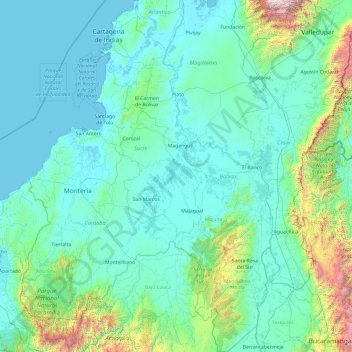
Name: Bolívar topographic map, elevation, terrain.

Location: Bolívar, RAP Caribe, Colombia (6.99931 -76.19046 10.80111 -73.74780)

Average elevation: 352 m

Minimum elevation: -2 m

Maximum elevation: 4,922 m

Other topographic maps

Click on a map to view its topography, its elevation and its terrain.

Medellín

Colombia > Antioquia > Medellín

Medellín has 16 comunas (districts), 5 corregimientos (townships), and 271 barrios (neighborhoods). The metropolitan area of Medellín lies within the Aburrá valley at an elevation of 1,500 metres (4,900 feet) above sea level and is bisected by the Medellín River (also called Porce), which flows northward.…

Average elevation: 2,098 m

Támesis

Colombia > Antioquia > Támesis

Támesis is a town and municipality in the Colombian department of Antioquia. Part of the subregion of Southwestern Antioquia. Located at an elevation of 1,638 m (5,374 ft) above sea level, it was established in 1858. The local economy is based on agriculture.

Average elevation: 1,718 m

Bogota

Colombia

The city is located in the center of Colombia, on a high plateau known as the Bogotá savanna, part of the Altiplano Cundiboyacense located in the Eastern Cordillera of the Andes. Its altitude averages 2,640 meters (8,660 ft) above sea level. Subdivided into 20 localities, Bogotá has an area of 1,587 square…

Average elevation: 2,735 m

San Rafael

Colombia > Antioquia > San Rafael

Average elevation: 1,196 m

Sabaneta

Colombia > Antioquia > Sabaneta

Its topography varies from flat reliefs and slight hills to places with steep slopes. Its most notable heights are those of Piedras Blancas (2,650 mamsl) in La Romera, the Cuchilla Santa Teresa (2,200 mamsl), the hill of Los Gallinazos in Pan de Azúcar (1,800 mamsl), the hill Morrón, La Siberia and the Ancón.

Average elevation: 1,787 m

Jericó

Colombia > Antioquia > Jericó > Cabecera Municipal Jericó

Average elevation: 1,813 m

Volcán Nevado del Ruiz

Colombia > Tolima

The summit of the volcano has steep slopes inclining from 20 to 30 degrees. At lower elevations, the slopes become less steep; their inclination is about 10 degrees. From there on, foothills stretch almost to the edge of the Magdalena River, north of the volcano and the Cauca River to the west. On the two…

Average elevation: 5,119 m

San Rafael

Colombia > Sucre > Ovejas

Average elevation: 195 m

Lousiana

Colombia > Magdalena > San Zenón

Average elevation: 51 m

El Hato

Colombia > Cundinamarca > Sesquilé

Average elevation: 2,871 m

Colombia

Colombia > Tolima > Fresno

Average elevation: 1,348 m

Cartagena

Colombia > Bolívar > Cartagena

Average elevation: 21 m

San Vicente

Colombia > Antioquia > San Vicente

Average elevation: 2,191 m

Pico Simón Bolívar

Colombia > Magdalena > Aracataca

Pico Simón Bolívar is possibly the highest mountain in Colombia, with an estimated height of 5,720 metres (18,770 ft). Pico Bolívar and the neighbouring summit of Pico Cristóbal Colón are the two highest peaks in Colombia and are very nearly equal in elevation. The height difference is about 7 meters. For…

Average elevation: 5,174 m

Sopetrán

Colombia > Antioquia > Sopetrán

Average elevation: 878 m

Chinauta corregimiento

Colombia > Cundinamarca

Average elevation: 1,166 m

La Chamba

Colombia > Tolima > Guamo

Average elevation: 292 m

El Jardín

Colombia > Valle del Cauca > Cali

Average elevation: 1,405 m

La Chapa

Colombia > Antioquia > El Carmen de Viboral

Average elevation: 2,372 m

Caldas

Colombia > Antioquia > Caldas

Average elevation: 2,008 m

Doradal

Colombia > Antioquia

Average elevation: 255 m

Cerritos

Colombia > Guaviare > El Retorno

Average elevation: 265 m

Puerto Frazadas

Colombia > Valle del Cauca > Tuluá

Average elevation: 1,777 m

Manaca

Colombia > Chocontá

Average elevation: 2,736 m

Normandia

Colombia > Huila > Pitalito > Bruselas

Average elevation: 1,700 m

La Esperanza

Colombia > Magdalena > El Banco

Average elevation: 28 m

Bateas

Colombia > Tibacuy

Average elevation: 1,353 m

Toche

Colombia > Tolima > Ibagué

Average elevation: 2,357 m

Sajonia

Colombia > Antioquia > Rionegro

Average elevation: 2,258 m

El Rosa

Colombia > Nariño > Aldana

Average elevation: 3,188 m

Cerro Chimayoy

Colombia > Nariño > Belén

Average elevation: 2,644 m

Andes

Colombia > Antioquia > Andes

Andes is a municipality and town in the Antioquia Department, Colombia. Part of the sub-region of Southwestern Antioquia, it is located on the western Colombian Andes mountain range. Andes was founded on 13 March 1852 by Pedro Antonio Restrepo Escobar. Its elevation is 1,360 metres above sea level with an…

Average elevation: 1,559 m

Río Upía

Colombia > Boyacá > Aquitania

Average elevation: 3,178 m

Vda. La Estrella

Colombia > Magdalena > Santa Marta

Average elevation: 267 m

Mayorquín

Colombia > Valle del Cauca > Buenaventura

Average elevation: 13 m

Galeras

Colombia > Nariño > Consacá

Numerous minor tremors and ash emissions since March 2006 culminated on 12 July 2006 in three explosive eruptions, producing an ash and gas column reaching an altitude of 8 kilometres (5.0 mi). Rock falls and pyroclastic flows were reported from towns as distant as Consacá, 11.4 kilometres (7.1 mi) west of…

Average elevation: 3,847 m

Fredonia

Colombia > Antioquia > Fredonia

Average elevation: 1,631 m

Maicao

Colombia > La Guajira > Maicao

The municipality of Maicao borders to the north with the municipalities of Uribia and Manaure; to the east with the Venezuela; to the south with the municipality of Albania and to the west with the municipality of Riohacha covering a total area of 1,782 km2 and at altitude over sea level of 52 m.

Average elevation: 51 m

San Pedro de la Sierra

Colombia > Magdalena > Ciénaga

Average elevation: 1,281 m

Granadillo

Colombia > Antioquia > Abejorral

Average elevation: 1,749 m

Apiay

Colombia > Meta > Villavicencio

Average elevation: 376 m

San Vicente

Colombia > Antioquia > San Vicente

Average elevation: 2,191 m

Loma De Chirajara

Colombia > Guayabetal

Average elevation: 1,872 m

Cerro Angimaloa

Colombia > La Guajira > Dibulla

Average elevation: 3,570 m

La Guajira

Colombia > Meta > Mesetas

Average elevation: 931 m

Cerro Kennedy

Colombia > Magdalena > Santa Marta

Average elevation: 2,366 m

La Albania

Colombia > Antioquia > Titiribí

Average elevation: 1,483 m

Santa Fe

Colombia > Antioquia > Cáceres

Average elevation: 86 m

Chamon

Colombia > Cauca > Guapi

Average elevation: 2 m

Caucasia

Colombia > Antioquia > Caucasia

The municipality of Caucasia is located at the northern department of Antioquia, on the border with the department of Córdoba and the subregion of Bajo Cauca Antioquia. It lies at an altitude of 150 m (490 ft) above sea level. Its territory is a flat area with small ridges in the north and west and south. It…

Average elevation: 63 m

Guachaca

Colombia > Magdalena > Santa Marta

Average elevation: 50 m

Las Botas

Colombia > Cauca > El Tambo

Average elevation: 1,729 m

Colu

Colombia > Bolívar > María la Baja

Average elevation: 15 m

Alto de Anchicayá

Colombia > Valle del Cauca > Cali

Average elevation: 1,348 m

Barrancabermeja

Colombia > Santander > Barrancabermeja

Average elevation: 82 m

Cañaveral

Colombia > Antioquia > San Carlos > San Carlos

Average elevation: 1,136 m

El Morro

Colombia > Antioquia > Sonsón

Average elevation: 1,898 m

Rionegro

Colombia > Antioquia > Rionegro

The city of Rionegro is located at 6°9′18″N 75°22′48″W / 6.15500°N 75.38000°W / 6.15500; -75.38000, at an average elevation of 2,125 metres (6,972 ft) above sea level. The average annual precipitation varies between 1,800 and 2,500 millimetres (71 and 98 in) with an average temperature of…

Average elevation: 2,232 m

Angelia

Colombia > Casanare > Yopal

Average elevation: 211 m

Baru

Colombia > Córdoba > Tierralta

Average elevation: 38 m

Rose Cay

Colombia > San Andrés

Average elevation: 5 m

Cerro Mavicure

Colombia > Guainía > Inírida

Average elevation: 130 m

Santa Elena

Colombia > Antioquia > Medellín

Average elevation: 2,547 m

Sierra Nevada de Santa Marta

Colombia > Magdalena > Aracataca

The Sierra Nevada de Santa Marta (English: Snow-Covered Mountain Range of Saint Martha) is an isolated mountain range in northern Colombia, separate from the Andes range that runs through the north of the country. Reaching an elevation of 5,700 m (18,700 ft) just 42 km (26 mi) from the Caribbean coast, the…

Average elevation: 5,013 m

Cerro Los Alpes

Colombia > Paratebueno

Average elevation: 486 m

Andes

Colombia > Antioquia > Andes

Andes is a municipality and town in the Antioquia Department, Colombia. Part of the sub-region of Southwestern Antioquia, it is located on the western Colombian Andes mountain range. Andes was founded on 13 March 1852 by Pedro Antonio Restrepo Escobar. Its elevation is 1,360 metres above sea level with an…

Average elevation: 1,559 m

Támesis

Colombia > Antioquia > Támesis

Támesis is a town and municipality in the Colombian department of Antioquia. Part of the subregion of Southwestern Antioquia. Located at an elevation of 1,638 m (5,374 ft) above sea level, it was established in 1858. The local economy is based on agriculture.

Average elevation: 1,718 m

Sonsón

Colombia > Antioquia > Sonsón

Average elevation: 2,455 m

Tigrera

Colombia > Magdalena > Santa Marta

Average elevation: 306 m

Barranquilla

Colombia > Atlántico > Barranquilla

Average elevation: 27 m

Andes

Colombia > Antioquia > Andes

Andes is a municipality and town in the Antioquia Department, Colombia. Part of the sub-region of Southwestern Antioquia, it is located on the western Colombian Andes mountain range. Andes was founded on 13 March 1852 by Pedro Antonio Restrepo Escobar. Its elevation is 1,360 metres above sea level with an…

Average elevation: 1,559 m

Sitio Nuevo

Colombia > Córdoba > Lorica

Average elevation: 4 m

Maimi

Colombia > Santander > Sabana de Torres

Average elevation: 147 m

Coconuco

Colombia > Cauca > Puracé

Average elevation: 2,721 m

Cerro El Volador

Colombia > Antioquia > Medellín

Average elevation: 1,500 m

Caucasia

Colombia > Antioquia > Caucasia

The municipality of Caucasia is located at the northern department of Antioquia, on the border with the department of Córdoba and the subregion of Bajo Cauca Antioquia. It lies at an altitude of 150 m (490 ft) above sea level. Its territory is a flat area with small ridges in the north and west and south. It…

Average elevation: 63 m

Papuri

Colombia > Vaupés > Yavaraté

Average elevation: 162 m

Las Palma

Colombia > Santander > Macaravita

Average elevation: 2,722 m

Soatá

Colombia > Boyacá > Soatá

Average elevation: 2,071 m

Nurember

Colombia > Meta > Puerto Gaitán

Average elevation: 185 m

Campamento

Colombia > Antioquia > Campamento

Campamento is a town and municipality in the Colombian department of Antioquia. Part of the subregion of Northern Antioquia, it lies at an altitude of 1,700 m (5,600 ft) above sea level. It is a little town, in the middle of the Andes.It borders on the north with the municipalities of Yarumal and Anorí, on…

Average elevation: 1,607 m

La Marina

Colombia > Tolima > Chaparral

Average elevation: 1,737 m

Andes

Colombia > Antioquia > Andes

Andes is a municipality and town in the Antioquia Department, Colombia. Part of the sub-region of Southwestern Antioquia, it is located on the western Colombian Andes mountain range. Andes was founded on 13 March 1852 by Pedro Antonio Restrepo Escobar. Its elevation is 1,360 metres above sea level with an…

Average elevation: 1,559 m

El Placer

Colombia > Valle del Cauca > Buga

Average elevation: 2,266 m

Yolombito

Colombia > Caldas > Marulanda

Average elevation: 3,033 m

San Vicente

Colombia > Antioquia > San Vicente

Average elevation: 2,191 m

Las Rojas

Colombia > Norte de Santander > Ocaña > Abrego

Average elevation: 1,846 m

Manizales

Colombia > Caldas > Manizales

Manizales is the capital city of one of the smallest Colombian departments. The city is described as having an "abrupt topography", and lies on the Colombian Central Mountain Range (part of the longest continental mountain range, the Andes), with a great deal of ridgelines and steep slopes, which, combined…

Average elevation: 2,010 m

Santa Lucia

Colombia > Meta > Puerto Rico

Average elevation: 248 m

Guanica Molina

Colombia > Boyacá > Garagoa

Average elevation: 1,906 m

Leticia

Colombia > Amazonas

Leticia (Spanish pronunciation: [leˈtisja]) is the southernmost city in the Republic of Colombia, capital of the department of Amazonas, Colombia's southernmost town (4.09° south 69.57° west) and one of the major ports on the Amazon River. It has an elevation of 96 meters (315') above sea level and an…

Average elevation: 71 m

Tenjo

Colombia > Tenjo

Average elevation: 2,682 m

Sabaneta

Colombia > Antioquia > Sabaneta

Its topography varies from flat reliefs and slight hills to places with steep slopes. Its most notable heights are those of Piedras Blancas (2,650 mamsl) in La Romera, the Cuchilla Santa Teresa (2,200 mamsl), the hill of Los Gallinazos in Pan de Azúcar (1,800 mamsl), the hill Morrón, La Siberia and the Ancón.

Average elevation: 1,787 m