
Ciego de Avila topographic map
Interactive map
Click on the map to display elevation.
About this map
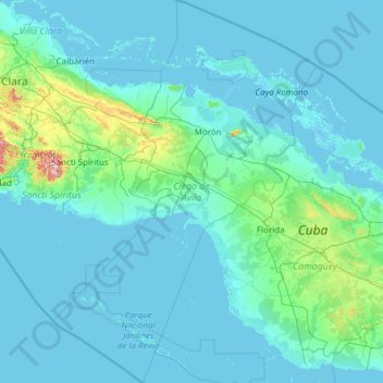
Name: Ciego de Avila topographic map, elevation, terrain.
Location: Ciego de Avila, Cuba (20.61295 -79.61426 22.88217 -77.93396)
Average elevation: 31 m
Minimum elevation: -4 m
Maximum elevation: 751 m
Other topographic maps
Click on a map to view its topography, its elevation and its terrain.
Havana
Cuba > Havana > La Habana Vieja
There are low hills on which the city lies rise gently from the waters of the straits. A noteworthy elevation is the 200-foot-high (60-meter) limestone ridge that slopes up from the east and culminates in the heights of La Cabaña and El Morro, the sites of Spanish fortifications overlooking the eastern bay.…
Average elevation: 30 m