
Kettering topographic map
Interactive map
Click on the map to display elevation.
About this map
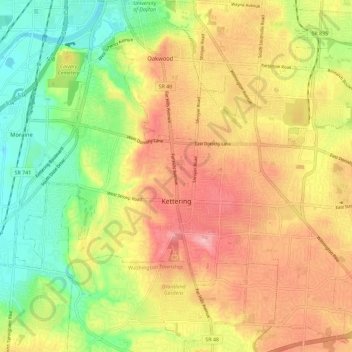
Name: Kettering topographic map, elevation, terrain.
Location: Kettering, Montgomery County, Ohio, United States (39.65495 -84.21473 39.73652 -84.09999)
Average elevation: 275 m
Minimum elevation: 213 m
Maximum elevation: 334 m
Other topographic maps
Click on a map to view its topography, its elevation and its terrain.
Patterson
United States > Ohio > Montgomery County > Dayton
Patterson, Dayton, Montgomery County, Ohio, 45408, United States
Average elevation: 233 m
Oakland
United States > Ohio > Montgomery County > Dayton
Oakland, Dayton, Montgomery County, Ohio, 45403, United States
Average elevation: 269 m
Washington Township
United States > Ohio > Montgomery County
Washington Township, Montgomery County, Ohio, United States
Average elevation: 285 m
North Riverdale
United States > Ohio > Montgomery County > Dayton
North Riverdale, Dayton, Montgomery County, Ohio, 45405, United States
Average elevation: 254 m
Shakertown
United States > Ohio > Montgomery County > Kettering
Shakertown, Kettering, Montgomery County, Ohio, 45420, United States
Average elevation: 282 m
Centerville
United States > Ohio > Montgomery County
Centerville, Montgomery County, Ohio, United States
Average elevation: 287 m
Miami Township
United States > Ohio > Montgomery County
Miami Township, Montgomery County, Ohio, United States
Average elevation: 272 m
Hearthstone
United States > Ohio > Montgomery County > Dayton
Hearthstone, Dayton, Montgomery County, Ohio, 45420, United States
Average elevation: 273 m
Dayton
United States > Ohio > Montgomery County
Dayton, Montgomery County, Ohio, United States
Average elevation: 270 m
Dayton
United States > Ohio > Montgomery County > Dayton
Dayton, Montgomery County, Ohio, 45423, United States
Average elevation: 270 m
Moraine
United States > Ohio > Montgomery County
Moraine, Montgomery County, Ohio, 45439, United States
Average elevation: 254 m