
Kampung Sungai Serai topographic map
Interactive map
Click on the map to display elevation.
About this map
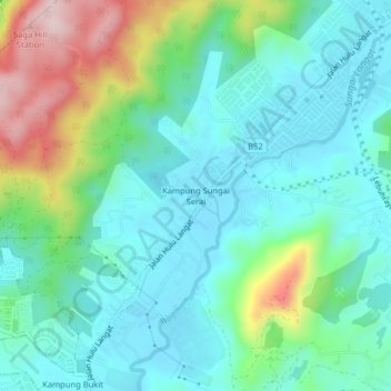
Name: Kampung Sungai Serai topographic map, elevation, terrain.
Average elevation: 127 m
Minimum elevation: 37 m
Maximum elevation: 400 m
Other topographic maps
Click on a map to view its topography, its elevation and its terrain.
Semungkis River
Malaysia > Selangor > Kajang Municipal Council > Batu 14 Hulu Langat
Average elevation: 186 m
Sungai Tekali
Malaysia > Selangor > Kajang Municipal Council > Batu 14 Hulu Langat
Average elevation: 79 m
Semungkis River
Malaysia > Selangor > Kajang Municipal Council > Batu 14 Hulu Langat
Average elevation: 186 m