
Wrenbury topographic map
Interactive map
Click on the map to display elevation.
About this map
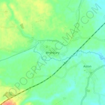
Name: Wrenbury topographic map, elevation, terrain.
Location: Wrenbury, Cheshire East, England, CW5 8EP, United Kingdom (53.00364 -2.62356 53.04364 -2.58356)
Average elevation: 74 m
Minimum elevation: 59 m
Maximum elevation: 103 m
Cheshire East trails, hiking, mountain biking, running and outdoor activities
Other topographic maps
Click on a map to view its topography, its elevation and its terrain.
Peckforton Moss
United Kingdom > England > Cheshire East > Bulkeley > Peckforton
Average elevation: 100 m
Alderley Edge
United Kingdom > England > Cheshire East
Alderley Edge is 6 miles (10 km) northwest of Macclesfield and 12 miles (19 km) south of Manchester, at the base of a steep and thickly wooded sandstone escarpment, Alderley Edge, which is the area's chief topographical feature and overlooks the Cheshire Plain.
Average elevation: 91 m