
Herzliya topographic map
Interactive map
Click on the map to display elevation.
About this map
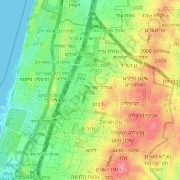
Name: Herzliya topographic map, elevation, terrain.
Location: Herzliya, Tel Aviv Subdistrict, Tel Aviv District, Israel (32.14402 34.79155 32.19648 34.86463)
Average elevation: 38 m
Minimum elevation: -1 m
Maximum elevation: 89 m
Other topographic maps
Click on a map to view its topography, its elevation and its terrain.
Bnei Brak
Bnei Brak, Tel Aviv Subdistrict, Tel Aviv District, Israel
Average elevation: 33 m
Herzliya
Israel > Tel Aviv District > Herzliya
Herzliya, Tel Aviv District, Israel
Average elevation: 45 m
Givatayim
Givatayim, Tel Aviv Subdistrict, Tel Aviv District, 5325707, Israel
Average elevation: 44 m
Ramat Gan
Ramat Gan, Tel Aviv Subdistrict, Tel Aviv District, Israel
Average elevation: 35 m
Jaffa
Israel > Tel Aviv District > Tel Aviv-Yafo
Jaffa, Tel Aviv-Yafo, Tel Aviv Subdistrict, Tel Aviv District, Israel
Average elevation: 12 m
Hilton Beach
Israel > Tel Aviv District > Tel Aviv-Yafo
Hilton Beach, Tel Aviv, The Old North - Northern part, Tel Aviv-Yafo, Tel Aviv Subdistrict, Tel Aviv District, no, Israel
Average elevation: 7 m
The Independence Park
Israel > Tel Aviv District > Tel Aviv-Yafo
The Independence Park, The Old North - Northern part, Tel Aviv-Yafo, Tel Aviv District, no, Israel
Average elevation: 7 m
Kiryat Ono
Israel > Tel Aviv District > Kiryat Ono
Kiryat Ono, Tel Aviv District, Israel
Average elevation: 66 m
Bat Yam
Israel > Tel Aviv District > Bat Yam
Bat Yam, Tel Aviv District, Israel
Average elevation: 21 m
Kiryat Ono
Israel > Tel Aviv District > Kiryat Ono
Kiryat Ono, Tel Aviv District, Israel
Average elevation: 58 m