
Capitol Reef National Park topographic map
Interactive map
Click on the map to display elevation.
About this map
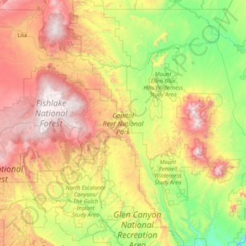
Name: Capitol Reef National Park topographic map, elevation, terrain.
Average elevation: 1,963 m
Minimum elevation: 1,119 m
Maximum elevation: 3,484 m
Other topographic maps
Click on a map to view its topography, its elevation and its terrain.
Skyline Rim Overlook
United States > Utah > Wayne County
Skyline Rim Overlook, Skyline View Road, Wayne County, Utah, United States
Average elevation: 1,439 m
Factory Butte
United States > Utah > Wayne County
Factory Butte, Wayne County, Utah, United States
Average elevation: 1,517 m
Dirty Devil River
United States > Utah > Wayne County
Dirty Devil River, Wayne County, Utah, United States
Average elevation: 1,635 m
Fruita
United States > Utah > Wayne County
Fruita, Wayne County, Utah, United States
Average elevation: 1,803 m
Canyonlands National Park
United States > Utah > Wayne County
Canyonlands National Park, Wayne County, Utah, United States
Average elevation: 1,640 m
Hanksville
United States > Utah > Wayne County
Hanksville, Wayne County, Utah, 84734, United States
Average elevation: 1,330 m