Geolocate

Gear up for your next adventure:

As an Amazon Associate, this site earns from qualifying purchases at no extra cost to you.

👉 Easily get elevation data in JSON, GeoTIFF and KML formats using Elevation API
Thank you for supporting this site ❤️
Make a donation

Williamson County topographic map

Click on the map to display elevation.

Gear up for your next adventure:

As an Amazon Associate, this site earns from qualifying purchases at no extra cost to you.

Gear up for your next adventure:

As an Amazon Associate, this site earns from qualifying purchases at no extra cost to you.

👉 Easily get elevation data in JSON, GeoTIFF and KML formats using Elevation API
Thank you for supporting this site ❤️
Make a donation

About this map

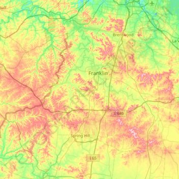
Name: Williamson County topographic map, elevation, terrain.

Location: Williamson County, Middle Tennessee, Tennessee, United States (35.69645 -87.21508 36.05272 -86.60003)

Average elevation: 227 m

Minimum elevation: 135 m

Maximum elevation: 369 m

Gear up for your next adventure:

As an Amazon Associate, this site earns from qualifying purchases at no extra cost to you.

👉 Easily get elevation data in JSON, GeoTIFF and KML formats using Elevation API
Thank you for supporting this site ❤️
Make a donation

Other topographic maps

Click on a map to view its topography, its elevation and its terrain.

House Mountain

United States > Tennessee > Knox County

House Mountain is a mountain located in Corryton, Tennessee, United States, about 8 miles (13 km) northeast of Knoxville. Rising to an elevation of 2,064 feet (629 m) above sea level, House Mountain is the highest point in Knox County.

Average elevation: 394 m

Pall Mall

United States > Tennessee > Fentress County

Average elevation: 315 m

Rather

United States > Tennessee > Fayette County

Average elevation: 141 m

Gear up for your next adventure:

As an Amazon Associate, this site earns from qualifying purchases at no extra cost to you.

Thank you for supporting this site ❤️
Make a donation

Washburn

United States > Tennessee > Grainger County

Average elevation: 465 m

Ladds

United States > Tennessee > Marion County

Average elevation: 291 m

Rural Vale

United States > Tennessee > Monroe County

Average elevation: 346 m

Mount Herman

United States > Tennessee > Moore County > Lynchburg

Average elevation: 327 m

Gear up for your next adventure:

As an Amazon Associate, this site earns from qualifying purchases at no extra cost to you.

Thank you for supporting this site ❤️
Make a donation

Christiana

United States > Tennessee > Rutherford County

Average elevation: 217 m

Cosby

United States > Tennessee > Cocke County

Average elevation: 483 m

Gear up for your next adventure:

As an Amazon Associate, this site earns from qualifying purchases at no extra cost to you.

Thank you for supporting this site ❤️
Make a donation

Eva

United States > Tennessee > Benton County

Average elevation: 124 m

Boyce

United States > Tennessee > Hamilton County > Chattanooga

Average elevation: 215 m

Gear up for your next adventure:

As an Amazon Associate, this site earns from qualifying purchases at no extra cost to you.

Thank you for supporting this site ❤️
Make a donation

Johntown

United States > Tennessee > Trousdale County

Average elevation: 174 m

Murphy Hills

United States > Tennessee > Knox County

Average elevation: 344 m

Melrose

United States > Tennessee > Blount County

Average elevation: 334 m

Williamsburg

United States > Tennessee > Sevier County

Average elevation: 412 m

Ponderosa Hills

United States > Tennessee > Knox County > Powell

Average elevation: 335 m

Gear up for your next adventure:

As an Amazon Associate, this site earns from qualifying purchases at no extra cost to you.

Thank you for supporting this site ❤️
Make a donation

Drummonds

United States > Tennessee > Tipton County

Average elevation: 122 m

Gear up for your next adventure:

As an Amazon Associate, this site earns from qualifying purchases at no extra cost to you.

Thank you for supporting this site ❤️
Make a donation

Powers

United States > Tennessee > Fayette County > Somerville

Average elevation: 120 m

Lost Ridge

United States > Tennessee > Anderson County > Clinton

Average elevation: 269 m

Gear up for your next adventure:

As an Amazon Associate, this site earns from qualifying purchases at no extra cost to you.

Thank you for supporting this site ❤️
Make a donation

Daniel Hill

United States > Tennessee > Bedford County

Average elevation: 294 m

Rickman

United States > Tennessee > Overton County

Average elevation: 333 m

Ellendale

United States > Tennessee > Shelby County > Bartlett

Average elevation: 96 m

Gear up for your next adventure:

As an Amazon Associate, this site earns from qualifying purchases at no extra cost to you.

Thank you for supporting this site ❤️
Make a donation

Holston Mountain

United States > Tennessee > Carter County

Average elevation: 1,033 m

Virgin Falls

United States > Tennessee > White County

Average elevation: 425 m

Plato

United States > Tennessee > Carter County

Average elevation: 946 m

Luttrell

United States > Tennessee > Loudon County

Average elevation: 319 m

Holladay

United States > Tennessee > Benton County

Average elevation: 138 m

Gear up for your next adventure:

As an Amazon Associate, this site earns from qualifying purchases at no extra cost to you.

Thank you for supporting this site ❤️
Make a donation

Norwood

United States > Tennessee > Knox County > Knoxville

Average elevation: 328 m

Flat Top

United States > Tennessee > Bledsoe County

Average elevation: 543 m

Gear up for your next adventure:

As an Amazon Associate, this site earns from qualifying purchases at no extra cost to you.

Thank you for supporting this site ❤️
Make a donation

Lovelace

United States > Tennessee > Greene County

Average elevation: 465 m

Gear up for your next adventure:

As an Amazon Associate, this site earns from qualifying purchases at no extra cost to you.

Thank you for supporting this site ❤️
Make a donation

Hampton

United States > Tennessee > Carter County

Average elevation: 674 m

Newfound Gap

United States > Tennessee > Sevier County

Average elevation: 1,442 m

Lonsdale

United States > Tennessee > Knox County > Knoxville

Average elevation: 307 m

Lovelace

United States > Tennessee > Greene County

Average elevation: 465 m

Gear up for your next adventure:

As an Amazon Associate, this site earns from qualifying purchases at no extra cost to you.

Thank you for supporting this site ❤️
Make a donation

Temple Hill

United States > Tennessee > Unicoi County

Average elevation: 838 m

Westpoint

United States > Tennessee > Lawrence County

Average elevation: 219 m

Norris Park

United States > Tennessee > Anderson County

Average elevation: 339 m

Hale

United States > Tennessee > Cumberland County > Crossville

Average elevation: 563 m

Gear up for your next adventure:

As an Amazon Associate, this site earns from qualifying purchases at no extra cost to you.

Thank you for supporting this site ❤️
Make a donation

Mayview Heights

United States > Tennessee > Knox County > Powell

Average elevation: 331 m

Disco

United States > Tennessee > Blount County

Average elevation: 263 m

Calderwood

United States > Tennessee > Blount County

Average elevation: 368 m

Harrtown

United States > Tennessee > Sullivan County

Average elevation: 511 m

Gear up for your next adventure:

As an Amazon Associate, this site earns from qualifying purchases at no extra cost to you.

Thank you for supporting this site ❤️
Make a donation

Cunningham

United States > Tennessee > Montgomery County

Average elevation: 196 m

Virgin Falls

United States > Tennessee > White County

Average elevation: 425 m

Southall

United States > Tennessee > Williamson County

Average elevation: 238 m

Gear up for your next adventure:

As an Amazon Associate, this site earns from qualifying purchases at no extra cost to you.

Thank you for supporting this site ❤️
Make a donation

Fair Oaks

United States > Tennessee > Davidson County > Nashville

Average elevation: 190 m

Gear up for your next adventure:

As an Amazon Associate, this site earns from qualifying purchases at no extra cost to you.

Thank you for supporting this site ❤️
Make a donation

Edgemoor

United States > Tennessee > Anderson County

Average elevation: 273 m

Etola

United States > Tennessee > Bradley County

Average elevation: 252 m

Carter

United States > Tennessee > Knox County

Average elevation: 293 m

Holly Hills

United States > Tennessee > Hamilton County

Average elevation: 257 m

Gear up for your next adventure:

As an Amazon Associate, this site earns from qualifying purchases at no extra cost to you.

Thank you for supporting this site ❤️
Make a donation

Gear up for your next adventure:

As an Amazon Associate, this site earns from qualifying purchases at no extra cost to you.

Thank you for supporting this site ❤️
Make a donation

Walden Ridge

United States > Tennessee > Campbell County

Average elevation: 401 m

Joelton

United States > Tennessee > Davidson County > Nashville

Average elevation: 236 m

Gear up for your next adventure:

As an Amazon Associate, this site earns from qualifying purchases at no extra cost to you.

Thank you for supporting this site ❤️
Make a donation

Taft

United States > Tennessee > Lincoln County

Average elevation: 273 m

Corryton

United States > Tennessee > Knox County

Average elevation: 319 m

Limestone Cove

United States > Tennessee > Unicoi County

Average elevation: 808 m

Gear up for your next adventure:

As an Amazon Associate, this site earns from qualifying purchases at no extra cost to you.

Thank you for supporting this site ❤️
Make a donation