
Peloponnese topographic map
Interactive map
Click on the map to display elevation.
About this map
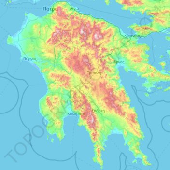
Name: Peloponnese topographic map, elevation, terrain.
Location: Peloponnese, Greece (36.38534 21.10507 38.34141 23.52452)
Average elevation: 257 m
Minimum elevation: -6 m
Maximum elevation: 2,293 m
Other topographic maps
Click on a map to view its topography, its elevation and its terrain.
Athens
Greece > Attica > Regional Unit of Central Athens
Owing to the rain shadow of the Pindus Mountains, annual precipitation of Athens is lower than most other parts of Greece, especially western Greece. As an example, Ioannina receives around 1,300 mm (51 in) per year, and Agrinio around 800 mm (31 in) per year. Daily average highs for July have been measured…
Average elevation: 168 m
Kynopiastes
Greece > Peloponnese, Western Greece and the Ionian > Corfu Regional Unit
Average elevation: 117 m
Athani
Greece > Peloponnese, Western Greece and the Ionian > Lefkada Regional Unit > Municipal Unit of Apollonioi
Average elevation: 325 m
Malia
Greece > Region of Crete > Heraklion Regional Unit > Malia Municipal Unit
Average elevation: 199 m
Athens
Greece > Attica > Regional Unit of Central Athens
Owing to the rain shadow of the Pindus Mountains, annual precipitation of Athens is lower than most other parts of Greece, especially western Greece. As an example, Ioannina receives around 1,300 mm (51 in) per year, and Agrinio around 800 mm (31 in) per year. Daily average highs for July have been measured…
Average elevation: 168 m
Ano Karnezaika
Greece > Peloponnese, Western Greece and the Ionian > Argolis Regional Unit > Municipal Unit of Asini
Average elevation: 235 m
Stratos
Greece > Peloponnese, Western Greece and the Ionian > Aetolia-Acarnania Regional Unit > Municipal Unit of Stratos
Average elevation: 54 m
Athens
Greece > Attica > Regional Unit of Central Athens
The southern section of the Athens metropolitan area (i.e., Elliniko, Athens Riviera) lies in the transitional zone between Mediterranean (Csa) and hot semi-arid climate (BSh), with its port-city of Piraeus being the most extreme example, receiving just 331.9 millimetres (13.07 in) per year. The areas to the…
Average elevation: 168 m
Neromylos
Greece > Peloponnese, Western Greece and the Ionian > Zakynthos Regional Unit > Arkadii Municipal Unit
Average elevation: 38 m
Neos Marmaras
Greece > Macedonia and Thrace > Chalkidiki Regional Unit > Sithonia Municipal Unit
Average elevation: 89 m
Kardamyli
Greece > Peloponnese, Western Greece and the Ionian > Messenia Regional Unit > Municipal Unit of Lefktro
Average elevation: 96 m
Kissos
Greece > Thessaly and Central Greece > Regional Unit of Magnesia > Municipal Unit of Mouresi
Average elevation: 482 m
Palaiokastritsa
Greece > Peloponnese, Western Greece and the Ionian > Corfu Regional Unit
Average elevation: 154 m
Exogi
Greece > Peloponnese, Western Greece and the Ionian > Ithaca Regional Unit
Average elevation: 102 m
Mykines
Greece > Peloponnese, Western Greece and the Ionian > Argolis Regional Unit > Municipal Unit of Mykines
Average elevation: 165 m
Vrachasi
Greece > Region of Crete > Lasithi Regional Unit > Vrachasi Municipal Unit
Average elevation: 363 m
Κροκεές
Greece > Peloponnese, Western Greece and the Ionian > Laconia Regional Unit
Average elevation: 256 m
Serres
Greece > Macedonia and Thrace > Serres Regional Unit
Serres is one of the administrative and economic centers of Northern Greece. The city is situated in a fertile plain at an elevation of about 70 metres (230 feet), some 24 kilometres (15 miles) northeast of the Strymon river and 69 km (43 mi) north-east of Thessaloniki, respectively. Serres' official municipal…
Average elevation: 317 m
Glyfa
Greece > Peloponnese, Western Greece and the Ionian > Corfu Regional Unit > Barbati
Average elevation: 227 m
Lentas
Greece > Region of Crete > Heraklion Regional Unit > Gortyna Municipal Unit
Average elevation: 97 m
Fiskardo
Greece > Peloponnese, Western Greece and the Ionian > Kefallonia Regional Unit > Erisos Municipal Unit
Average elevation: 52 m
Kalypso
Greece > Thessaly and Central Greece > Phthiotis Regional Unit > Municipal Unit of Dafnousia
Average elevation: 54 m
Eliki
Greece > Peloponnese, Western Greece and the Ionian > Achaia Regional Unit > Municipal Unit of Diakopto
Average elevation: 136 m
Χάνια
Greece > Thessaly and Central Greece > Regional Unit of Magnesia > Volos Municipality
Average elevation: 1,103 m
Nea Makri
Greece > Attica > Regional Unit of East Attica > Nea Makri Municipal Unit
Average elevation: 122 m
Pentalofos
Greece > Macedonia and Thrace > Thessaloniki Regional Unit > Kallithea Municipal Unit
Average elevation: 163 m
Στενά Νέστου
Greece > Macedonia and Thrace > Kavala Regional Unit > Paradisos
Average elevation: 449 m
Matsoukata
Greece > Peloponnese, Western Greece and the Ionian > Kefallonia Regional Unit > Erisos Municipal Unit
Average elevation: 103 m
Highly salted sea
Greece > Peloponnese, Western Greece and the Ionian > Aetolia-Acarnania Regional Unit > Municipal Unit of Etoliko
Average elevation: 2 m
Amfissa
Greece > Thessaly and Central Greece > Regional Unit of Phocis > Municipal Unit of Amfissa
Average elevation: 506 m
Doxa
Greece > Peloponnese, Western Greece and the Ionian > Arcadia Regional Unit > Municipal Unit of Tropaia
Average elevation: 552 m
Ύπατο
Greece > Thessaly and Central Greece > Regional Unit of Boeotia > Municipal Unit of Thebes
Average elevation: 251 m
Φαράγγι Βίκου
Greece > Epirus and Western Macedonia > Ioannina Regional Unit
Average elevation: 1,159 m
Kouvelles
Greece > Thessaly and Central Greece > Euboea Regional Unit > Styra Municipal Unit
Average elevation: 131 m
Βίτσα
Greece > Epirus and Western Macedonia > Ioannina Regional Unit
Vitsa (Greek: Βίτσα) is one of the largest villages of the central Zagori region, in northwestern Greece. It is situated at an altitude of 955m on a mountain slope near the Vikos gorge with roads linking it to Greek National Road 6. Vitsa is famous for its old double-arched bridge of Missios.
Average elevation: 965 m
Patras
Greece > Peloponnese, Western Greece and the Ionian > Achaia Regional Unit
A central feature of the urban geography of Patras is its division into upper and lower sections. This is the result of an interplay between natural geography and human settlement patterns; the lower section of the city (Kato Poli), which includes the 19th-century urban core and the port, is adjacent to the…
Average elevation: 283 m
Loutropigi
Greece > Thessaly and Central Greece > Karditsa Regional Unit > Municipal Unit of Menelaida
Average elevation: 563 m
Hymettus
Greece > Attica > Regional Unit of Central Athens
The highest point of the mountain range is Evzonas (Εύζωνας) with an elevation of 1,026 m (3,366 ft). The 16 km (9.9 mi) length of Hymettus stretches from Athens to the Saronic Gulf. It is 6 to 7 km from east to west. In ancient times, the highest point was known as Megas Hymettos and the southern peaks…
Average elevation: 680 m
Sidari
Greece > Peloponnese, Western Greece and the Ionian > Corfu Regional Unit
Average elevation: 13 m
Δάσος Φρακτού
Greece > Macedonia and Thrace > Drama Regional Unit > Paranesti Municipality
Average elevation: 1,347 m
Argalasti
Greece > Thessaly and Central Greece > Regional Unit of Magnesia > Municipal unit of Argalasti
Average elevation: 226 m
Revmatia
Greece > Peloponnese, Western Greece and the Ionian > Messenia Regional Unit
Average elevation: 542 m
Ioannina
Greece > Epirus and Western Macedonia > Ioannina Regional Unit
According to the 2021 census, the city population was 64,896 while the municipality had 113,978 inhabitants. It lies at an elevation of approximately 500 metres (1,640 feet) above sea level, on the western shore of Lake Pamvotis (Παμβώτις). Ioannina is located 410 km (255 mi) northwest of Athens, 260…
Average elevation: 724 m
Pezoula
Greece > Thessaly and Central Greece > Karditsa Regional Unit > Nevropoli Agrafon Municipal Unit
Average elevation: 1,032 m