
Peloponnese topographic map
Interactive map
Click on the map to display elevation.
About this map
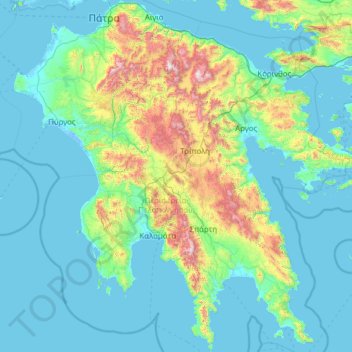
Name: Peloponnese topographic map, elevation, terrain.
Location: Peloponnese, Greece (36.38525 21.10507 38.34141 23.52452)
Average elevation: 257 m
Minimum elevation: -6 m
Maximum elevation: 2,293 m
Other topographic maps
Click on a map to view its topography, its elevation and its terrain.
Kefalonia
Greece > Peloponnese, Western Greece and the Ionian > Kefallonia Regional Unit
Average elevation: 60 m
Sithonia
Greece > Macedonia and Thrace > Chalkidiki Regional Unit > Toroni Municipal Unit
Average elevation: 473 m
Thiva
Greece > Thessaly and Central Greece > Regional Unit of Boeotia > Municipal Unit of Thebes
Thebes is situated in a plain, between Lake Yliki (ancient Hylica) to the north, and the Cithaeron mountains, which divide Boeotia from Attica, to the south. Its elevation is 215 m (705 ft) above mean sea level. It is about 50 km (31 mi) northwest of Athens, and 100 km (62 mi) southeast of Lamia. The A1…
Average elevation: 218 m
Asimi
Greece > Region of Crete > Heraklion Regional Unit > Kofinas Municipal Unit
Average elevation: 288 m
Kombi
Greece > Peloponnese, Western Greece and the Ionian > Messenia Regional Unit > Koroni Municipal Unit
Average elevation: 64 m
Agios Spiridon
Greece > Peloponnese, Western Greece and the Ionian > Corfu Regional Unit
Average elevation: 21 m
Pavliani
Greece > Thessaly and Central Greece > Phthiotis Regional Unit > Δημοτική Ενότητα Παύλιανης
Average elevation: 1,124 m
Agios Nektarios
Greece > Attica > Regional Unit of West Attica > Municipal Unit of Vilia
Average elevation: 695 m
Gythio
Greece > Peloponnese, Western Greece and the Ionian > Laconia Regional Unit > Gytheio Municipal Unit
Average elevation: 40 m
Leonidio
Greece > Peloponnese, Western Greece and the Ionian > Arcadia Regional Unit > Municipal Unit of Leonidio
Average elevation: 378 m
Pesada
Greece > Peloponnese, Western Greece and the Ionian > Kefallonia Regional Unit
Average elevation: 75 m
Oia
Greece > Aegean > Thira Regional Unit > Ia Municipal Unit
The village is located on top of a hill, at about 150 m (500 ft) elevation, and known as the "Eagles nest" from where Palia and Nea Kameni volcanoes are seen and also the island of Therasia. It is situated to the north of the island and Fira is at distance of 11 km (7 mi). The main street in the town, in the…
Average elevation: 20 m
Chora
Greece > Peloponnese, Western Greece and the Ionian > Messenia Regional Unit
Chora is located in the southwestern part of Greece, in the peripheral unit of Messinia in Greece. It is 273 kilometers away from Athens, 205 kilometers away from Patras and 55 kilometers away from Kalamata. It has an altitude of 294 meters and it is built on the foothills of Aigaleo Mountain and 12 kilometers…
Average elevation: 324 m
Krioneri
Greece > Region of Crete > Lasithi Regional Unit > Itanos Municipal Unit
Average elevation: 574 m
Arkalochori
Greece > Region of Crete > Heraklion Regional Unit > Arkalochori Municipal Unit
Average elevation: 370 m
Kosmas
Greece > Peloponnese, Western Greece and the Ionian > Arcadia Regional Unit > Municipal Unit of Kosmas
Kosmas (Greek: Κοσμάς) is a mountain village and a former community in Arcadia, Peloponnese, Greece. It is considered a traditional settlement. Since the 2011 local government reform it is part of the municipality South Kynouria, of which it is a municipal unit. The municipal unit has an area of 85.220…
Average elevation: 1,097 m
Argalasti
Greece > Thessaly and Central Greece > Regional Unit of Magnesia > Municipal unit of Argalasti
Average elevation: 226 m
Mavromati
Greece > Peloponnese, Western Greece and the Ionian > Messenia Regional Unit
Average elevation: 374 m
Ermioni
Greece > Peloponnese, Western Greece and the Ionian > Argolis Regional Unit > Municipal Unit of Ermioni
Average elevation: 55 m
Kastelli
Greece > Region of Crete > Heraklion Regional Unit > Kastelli Municipal Unit
Average elevation: 366 m
Kirra
Greece > Thessaly and Central Greece > Regional Unit of Phocis > Municipal Unit of Itea
Average elevation: 84 m
Λεφόκαστρο
Greece > Thessaly and Central Greece > Regional Unit of Magnesia > Municipal unit of Argalasti
Average elevation: 86 m
Platanos
Greece > Peloponnese, Western Greece and the Ionian > Elis Regional Unit
Average elevation: 93 m
Eliki
Greece > Peloponnese, Western Greece and the Ionian > Achaia Regional Unit > Municipal Unit of Diakopto
Average elevation: 136 m
Irakleia
Greece > Macedonia and Thrace > Serres Regional Unit > Iraklia Municipal Unit
Average elevation: 33 m
Polilimnio
Greece > Peloponnese, Western Greece and the Ionian > Messenia Regional Unit > Kalochori
Average elevation: 314 m
Pistamata
Greece > Peloponnese, Western Greece and the Ionian > Laconia Regional Unit
Average elevation: 553 m
Pindus
Greece > Thessaly and Central Greece > Karditsa Regional Unit
The Pindus (also Pindos or Pindhos; Greek: Πίνδος, romanized: Píndos; Albanian: Pindet; Aromanian: Pindu) is a mountain range located in Northern Greece and Southern Albania. It is roughly 160 km (100 miles) long, with a maximum elevation of 2,637 metres (8652') (Mount Smolikas). Because it runs along…
Average elevation: 1,510 m
Stalida
Greece > Region of Crete > Heraklion Regional Unit > Malia Municipal Unit
Average elevation: 98 m
Agios Markos
Greece > Peloponnese, Western Greece and the Ionian > Corfu Regional Unit
Average elevation: 218 m
Κυπαρίσσι
Greece > Thessaly and Central Greece > Phthiotis Regional Unit > Municipal Unit of Atalanti
Average elevation: 55 m
Meskla
Greece > Region of Crete > Chania Regional Unit
Meskla (Μεσκλά) is a village in the municipality of Platanias, a regional unit of Chania, western Crete, in Greece. According to the 2021 census it has 268 inhabitants. It is built on an altitude of 200 meters, at the northern foothills of the White Mountains, in the valley of the river Keritis. It is 21…
Average elevation: 422 m
Drepano
Greece > Peloponnese, Western Greece and the Ionian > Argolis Regional Unit > Municipal Unit of Asini
Average elevation: 36 m
Ριζόμυλος
Greece > Peloponnese, Western Greece and the Ionian > Messenia Regional Unit
Average elevation: 63 m
Toroni
Greece > Macedonia and Thrace > Chalkidiki Regional Unit > Toroni Municipal Unit
Average elevation: 48 m
Analipsi
Greece > Peloponnese, Western Greece and the Ionian > Corfu Regional Unit > Agios Markos
Average elevation: 141 m
Mandra
Greece > Peloponnese, Western Greece and the Ionian > Messenia Regional Unit
Average elevation: 239 m
Kokkala
Greece > Peloponnese, Western Greece and the Ionian > Elis Regional Unit > Βαρθολομιό
Average elevation: 12 m
Agios Andreas
Greece > Region of Crete > Lasithi Regional Unit > Sitia Municipal Unit
Average elevation: 92 m
Vatos
Greece > Peloponnese, Western Greece and the Ionian > Corfu Regional Unit
Average elevation: 65 m
Νέα Μεσάγγαλα
Greece > Thessaly and Central Greece > Larisa Regional Unit > Municipal Unit of Kato Olympos
Average elevation: 0 m
Παραλία Κουλούρας
Greece > Thessaly and Central Greece > Larisa Regional Unit > Municipal Unit of Kato Olympos > Νέα Μεσάγγαλα
Average elevation: 0 m
Ellinika
Greece > Peloponnese, Western Greece and the Ionian > Aetolia-Acarnania Regional Unit > Municipal Unit of Iera Poli Messologhiou
Average elevation: 658 m
Artemisio
Greece > Peloponnese, Western Greece and the Ionian > Argolis Regional Unit > Municipal Unit of Lyrkeia
Average elevation: 978 m
Papapouli
Greece > Thessaly and Central Greece > Larisa Regional Unit > Municipal Unit of Kato Olympos
Average elevation: 10 m
Πηγάδι
Greece > Thessaly and Central Greece > Regional Unit of Magnesia > Municipal Unit of Pteleos
Average elevation: 26 m
Νεόκτιστα
Greece > Macedonia and Thrace > Thessaloniki Regional Unit > Stavroupoli Municipal Unit
Average elevation: 69 m
Παλαιό Κεραμίδι
Greece > Macedonia and Thrace > Pieria Regional Unit > Katerini Municipality
Average elevation: 114 m
Kourkoumelata
Greece > Peloponnese, Western Greece and the Ionian > Kefallonia Regional Unit
Average elevation: 103 m
Olympiaki Akti (Beach)
Greece > Macedonia and Thrace > Pieria Regional Unit > Katerini Municipality
Average elevation: 2 m
Πήλιο
Greece > Thessaly and Central Greece > Regional Unit of Magnesia > Municipal Unit of Zagora
Average elevation: 1,382 m
Agnanderi
Greece > Thessaly and Central Greece > Larisa Regional Unit > Municipal Unit of Kileler
Average elevation: 369 m
Paralia
Greece > Macedonia and Thrace > Pieria Regional Unit > Katerini Municipality
Average elevation: 5 m
Σκροπονέρια Βοιωτίας
Greece > Thessaly and Central Greece > Regional Unit of Boeotia > Municipal Unit of Akrefnia
Average elevation: 239 m
Kiato
Greece > Peloponnese, Western Greece and the Ionian > Corinthia Regional Unit > Municipal Unit of Sikyona
Average elevation: 32 m