Geolocate

Reykjavik topographic map

Interactive map

Click on the map to display elevation.

About this map

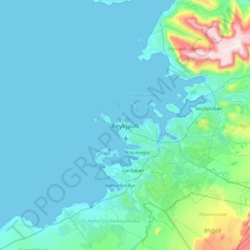
Name: Reykjavik topographic map, elevation, terrain.

Location: Reykjavik, Capital Region, 121, Iceland (63.98598 -22.10224 64.30598 -21.78224)

Average elevation: 89 m

Minimum elevation: -3 m

Maximum elevation: 897 m

Other topographic maps

Click on a map to view its topography, its elevation and its terrain.

Grundir

Iceland > Reykjavik

Grundir, Kjalarnes, Reykjavik, Capital Region, 116, Iceland

Average elevation: 30 m

Engey

Iceland > Reykjavik

Engey, Reykjavik, Capital Region, Iceland

Average elevation: 0 m

Vesturhöfn

Iceland > Reykjavik

Vesturhöfn, Vesturbær, Reykjavik, Capital Region, Iceland

Average elevation: 4 m

Hafravatn

Iceland > Reykjavik

Hafravatn, Hafravatnsvegur, Reykjavik, Capital Region, 270, Iceland

Average elevation: 109 m