
Glarus topographic map
Interactive map
Click on the map to display elevation.
About this map
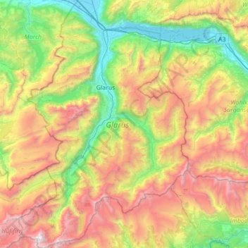
Name: Glarus topographic map, elevation, terrain.
Location: Glarus, Switzerland (46.79647 8.87123 47.17399 9.25258)
Average elevation: 1,612 m
Minimum elevation: 413 m
Maximum elevation: 3,565 m
Other topographic maps
Click on a map to view its topography, its elevation and its terrain.
Haldenstein
Switzerland > Grisons > Plessur > Chur
Before 2017, the municipality was located in the Fünf Dörfer sub-district of the Landquart district, after 2017 it was part of the Plessur Region. It is located north of Chur and on the left bank of the Rhine River. It consists of the haufendorf (an irregular, unplanned and quite closely packed village,…
Average elevation: 826 m
Eau-Rouge
Switzerland > Wallis > Entremont > Chamoille (Sembrancher) > Les Champmanins
Average elevation: 1,034 m
Les Briesses
Switzerland > Wallis > Sierre > Crans-Montana > Chermignon-d'en-Bas
Average elevation: 1,179 m
Horeweid
Switzerland > Bern > Interlaken-Oberhasli administrative district > Därligen
Average elevation: 1,162 m
Chironico
Switzerland > Ticino > Distretto di Leventina
The municipality is located in the Leventina district, on the right slope of the mid-Leventina valley at an elevation of 786 meters (2,579 ft). The municipality stretches from the Ticino river at the Biaschina-Schlucht (elevation 450 m (1,480 ft)) up to the Pizzo Campo Tencia (3,072 m (10,079 ft)) in the upper…
Average elevation: 1,026 m
Mase
Switzerland > Wallis > Hérens > Mont-Noble
The village is located in the Hérens district on the right bank of the Borgne and the left bank of the Rhone in the Val d'Hérens at an elevation of 1,345 m (4,413 ft). It consists of the village of Mase.
Average elevation: 1,272 m
Dents du Midi
Switzerland > Wallis > Monthey > Val-d'Illiez
The Dents du Midi are situated on the border between the communes of Val-d'Illiez and Evionnaz. The north face rises above the Val d'Illiez while the south face overlooks the Lac de Salanfe, an artificial reservoir. The ridge of the chain is situated at an altitude varying between 2,997 and 3,258 meters (9,833…
Average elevation: 2,440 m
Lac Vert
Switzerland > Wallis > Monthey > Val-d'Illiez
Lake Vert is a lake in the Chablais region of the canton of Valais, Switzerland. The lake is located in the municipality of Val-d'Illiez, at an elevation of 1972 metres, near the border with France. Lac de Chésery lies 600 metres north.
Average elevation: 1,932 m
Griesalp
Switzerland > Bern > Frutigen-Niedersimmental administrative district > Reichenbach im Kandertal
Average elevation: 1,730 m
Leiterli
Switzerland > Bern > Obersimmental-Saanen administrative district > Lenk
Average elevation: 1,791 m
Hasliberg Wasserwendi
Switzerland > Bern > Interlaken-Oberhasli administrative district
Average elevation: 1,247 m
Mase
Switzerland > Wallis > Hérens > Mont-Noble
The village is located in the Hérens district on the right bank of the Borgne and the left bank of the Rhone in the Val d'Hérens at an elevation of 1,345 m (4,413 ft). It consists of the village of Mase.
Average elevation: 1,272 m
Frasco
Switzerland > Ticino > Distretto di Locarno > Verzasca
The village is located in the Locarno district. It consists of the village of Frasco and multiple scattered settlements along the road in the upper Verzasca valley. The average elevation of the settlements is about 880 meters (2,890 ft).
Average elevation: 1,393 m
Kleine Scheidegg
Switzerland > Bern > Interlaken-Oberhasli administrative district > Lauterbrunnen > Kleine Scheidegg
Average elevation: 2,070 m
Wildhaus
Switzerland > St. Gallen > Wahlkreis Toggenburg > Wildhaus-Alt St. Johann
Average elevation: 1,244 m
Rüplisried
Switzerland > Bern > Bern-Mittelland administrative district > Mühleberg
Average elevation: 545 m
Torgon
Switzerland > Wallis > Monthey
Torgon is a village in the Swiss Alps, located in the canton of Valais. It lies on the western part of the canton, in the region of the Chablais, at an altitude of 1,085 metres. The village sits on a sunny terrace overlooking the Rhone valley, above Vionnaz. Politically Torgon belongs to the latter town.
Average elevation: 884 m
Berninapass
Switzerland > Grisons > Maloja > Pontresina
The building of the road began in 1842. Head of engineers was Rudolf Albertini (1821–1896) from Zuoz. The work was finished in 1865 and a hospice at an elevation of 2,307 metres (7,569 ft) was also opened. Since this time the road has been widened several times. Since 1965 it has been open all year round,…
Average elevation: 2,351 m
Sigriswiler Rothorn
Switzerland > Bern > Thun administrative district > Sigriswil
Average elevation: 1,552 m
Faulensee
Switzerland > Bern > Frutigen-Niedersimmental administrative district > Spiez
Average elevation: 638 m
Le Crêt
Switzerland > Vaud > District de la Riviera-Pays-d’Enhaut > Rougemont
Average elevation: 1,229 m
Eiger
Switzerland > Bern > Interlaken-Oberhasli administrative district > Grindelwald
Average elevation: 2,944 m
Fürten
Switzerland > Bern > Frutigen-Niedersimmental administrative district > Kandergrund
Average elevation: 1,402 m