
Tianjin topographic map
Interactive map
Click on the map to display elevation.
Tianjin
The city has 153 km (95 mi) of coastline and 1,137.48 kilometers (706.80 mi) of land border. It is located at the northern end of the Grand Canal of China, which connects with the Yellow and Yangtze Rivers. The municipality is generally flat and is swampy near the coast; however, it has hills in the north, where the Yan Mountains enter Tianjin. Tidal flats occur on the coastal plain adjacent to the city. The highest point in the municipality is Jiuding Peak (九顶山) in Ji County on the northern border with Hebei; the mountain has an altitude of 1,078.5 m (3,538 ft).
About this map
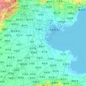
Name: Tianjin topographic map, elevation, terrain.
Location: Tianjin, China (36.57144 113.73200 40.25201 118.05867)
Average elevation: 64 m
Minimum elevation: -4 m
Maximum elevation: 2,561 m
Other topographic maps
Click on a map to view its topography, its elevation and its terrain.
Chongqing
The central urban area of Chongqing, or Chongqing proper, is a city of unique features. Built on mountains and partially surrounded by the Yangtze and Jialing rivers, it is known as a "mountain city" and a "city on rivers". The night scene of the city is very illuminated, with millions of lights and their…
Average elevation: 318 m
Hemu River
China > Xinjiang > Burqin County > Kom-Kanas Mongolian Ethnic Township
Average elevation: 1,732 m
Gasherbrum II
China > Xinjiang > Taxkorgan Tajik Autonomous County > Dafdar
Gasherbrum II is located on the border of Gilgit–Baltistan, Pakistan, and Xinjiang, China. It is part of the Karakoram mountain range in the Himalayas, and located at the top of the Baltoro Glacier. With an elevation of 8,034 metres (26,358 ft) it is the third-highest member of the Gasherbrum group, behind…
Average elevation: 7,098 m
Mount Wudang
China > Hubei > Danjiangkou City
Modern maps show the elevation of the highest of the peaks in the Wudang Shan "proper" as 1612 meters; however, the entire Wudangshan range has somewhat higher elevations elsewhere.
Average elevation: 1,172 m
Kawagarbo
China > Tibet > Chamdo City
The Kawa Karpo has over 20 peaks with permanent snow cover, including six peaks over 6,000 m (19,700 ft). Topographic extremes are immense, with vertical relief ranging from less than 2,000 m along the Mekong River on the east to 6,740 m on the summit of Kawa Karpo within 10 km horizontal distance. Even…
Average elevation: 5,809 m
Napahai Nature Reserve
China > Yunnan > Shangri-La > Jiantang > Chui Zongdala
Average elevation: 3,410 m
Yarkand
China > Xinjiang > Yarkant County
Yarkant County, also Shache County, also transliterated from Uyghur as Yakan County, is a county in the Xinjiang Uyghur Autonomous Region, China, located on the southern rim of the Taklamakan Desert in the Tarim Basin. It is one of 11 counties administered under Kashgar Prefecture. The county, usually referred…
Average elevation: 1,227 m