
Bugthorpe topographic map
Interactive map
Click on the map to display elevation.
About this map
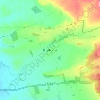
Name: Bugthorpe topographic map, elevation, terrain.
Average elevation: 55 m
Minimum elevation: 21 m
Maximum elevation: 123 m
East Riding of Yorkshire trails, hiking, mountain biking, running and outdoor activities
Other topographic maps
Click on a map to view its topography, its elevation and its terrain.
Willerby and Derringham Flood Alleviation Scheme
United Kingdom > England > East Riding of Yorkshire > Kirk Ella
Average elevation: 42 m
Burton Constable Hall
United Kingdom > England > East Riding of Yorkshire > West Newton
Average elevation: 18 m
Malton Lane Plantation
United Kingdom > England > East Riding of Yorkshire > Bugthorpe
Average elevation: 54 m
Stamford Bridge
United Kingdom > England > East Riding of Yorkshire > Stamford Bridge
Average elevation: 16 m
River Hull
United Kingdom > England > East Riding of Yorkshire > Brandesburton
Average elevation: 27 m
Airedale
United Kingdom > England > East Riding of Yorkshire
This valley is of great topographic significance as it provides low-altitude passes through the mid Pennines to the west coast known as the Aire Gap.
Average elevation: 58 m