
Canaria topographic map
Interactive map
Click on the map to display elevation.
About this map
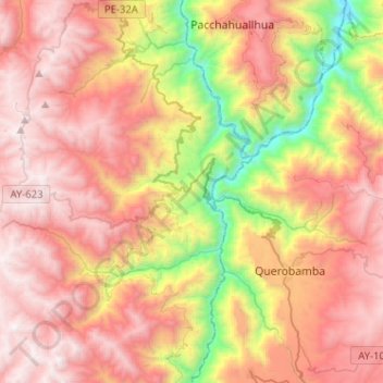
Name: Canaria topographic map, elevation, terrain.
Location: Canaria, Province of Víctor Fajardo, Ayacucho, Peru (-14.03349 -74.11894 -13.88719 -73.86305)
Average elevation: 3,527 m
Minimum elevation: 2,209 m
Maximum elevation: 4,582 m
Other topographic maps
Click on a map to view its topography, its elevation and its terrain.