
Saxnäs topographic map
Interactive map
Click on the map to display elevation.
About this map
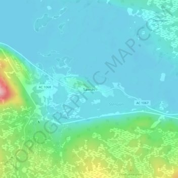
Name: Saxnäs topographic map, elevation, terrain.
Location: Saxnäs, Västerbotten County, 912 70, Sweden (64.95055 15.33159 64.99055 15.37159)
Average elevation: 567 m
Minimum elevation: 539 m
Maximum elevation: 709 m
Other topographic maps
Click on a map to view its topography, its elevation and its terrain.