
Donegal Bay topographic map
Interactive map
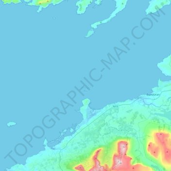
Click on the map to display elevation.
About this map
Name: Donegal Bay topographic map, elevation, terrain.
Average elevation: 37 m
Minimum elevation: -1 m
Maximum elevation: 644 m
Other topographic maps
Click on a map to view its topography, its elevation and its terrain.
Burren National Park
Glaciers also deposited numerous granite and limestone erratics on the pavements. The former were carried south across Galway Bay by the second-to-last glaciation. Granite boulders can be found mostly in the north of the Burren. The final ice cover came from the northeast and mostly deposited limestone…
Average elevation: 69 m
Ballyagran
Ireland > County Limerick > The Municipal District of Newcastle West
Average elevation: 97 m
Leixlip
British publisher and cartographer Samuel Lewis mentions Confey Castle in the first volume of his 1837 work A Topographical Dictionary of Ireland. In it, he comments that Confey's (or Confoy as he spells it) population was 165, had formerly had a town and a castle of some importance, which were noticed by…
Average elevation: 55 m
Coolnahila (Palmer)
Ireland > County Limerick > The Municipal District of Cappamore — Kilmallock
Average elevation: 39 m
County Wicklow
The county experiences a narrow annual temperature range. Typical daytime highs range from 17–22 °C (63–72 °F) throughout the county in July and August, with overnight lows in the 11–14 °C (52–57 °F) range, although temperatures in the mountains can be 5–10 °C (41–50 °F) lower. Mean January…
Average elevation: 166 m
Dundalk
The main part of the census town lies at sea level. Dún Dealgan Motte at Castletown is the highest point in the urban area at an elevation of 60 m (200 ft). The municipal district includes the Cooley Mountains, with Slieve Foy the highest of the peaks at an elevation of 589 m (1,932 ft).
Average elevation: 13 m
Templeglantine
Ireland > County Limerick > The Municipal District of Newcastle West
Average elevation: 189 m