
Bistrița topographic map
Interactive map
Click on the map to display elevation.
About this map
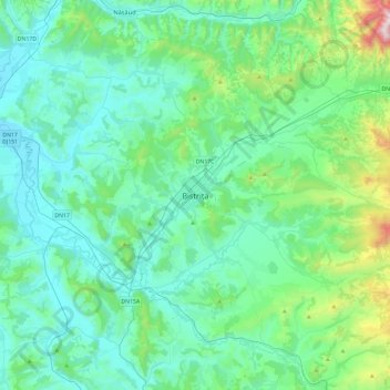
Name: Bistrița topographic map, elevation, terrain.
Location: Bistrița, Bistrița-Năsăud, 420057, Romania (46.97270 24.33639 47.29270 24.65639)
Average elevation: 463 m
Minimum elevation: 268 m
Maximum elevation: 1,518 m
Other topographic maps
Click on a map to view its topography, its elevation and its terrain.