
Nazareth topographic map
Interactive map
Click on the map to display elevation.
Nazareth
As of the early 1990s, no city plans drafted by Nazareth Municipality have been approved by the government (both the British Mandate and later Israel) since 1942. This has left many people in Nazareth who vote in the city's municipal elections and receive services from its municipality effectively outside of the city's jurisdiction. Such areas include the Sharqiya and Jabal el-Daula quarters which are in Nazareth Illit's jurisdiction and whose residents had to acquire building permits from the latter city. Similarly, the Bilal neighborhood of the Safafra Quarter is located within Reineh's jurisdiction. In 1993, the residents of Bilal became official residents of Reineh. Nazareth's municipal plans for expansion prior to the establishment of Nazareth Illit, were to the north and east, areas that the latter city now occupy. Arab satellite towns are closely located to the north, west and southwest. Thus, the remaining area within the city's municipal boundaries available for expansion were to the northwest and the south, where the topography restricted urban development. After lobbying the Knesset and the Interior Ministry, el-Zoubi was able to have areas to the northwest of the city annexed to the municipality.
About this map
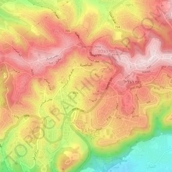
Name: Nazareth topographic map, elevation, terrain.
Location: Nazareth, Jezreel Subdistrict, North District, Israel (32.67995 35.27331 32.72247 35.31245)
Average elevation: 359 m
Minimum elevation: 124 m
Maximum elevation: 505 m
Other topographic maps
Click on a map to view its topography, its elevation and its terrain.
Sea of Galilee
After 5 years of drought as of 2018, Sea of Galilee is expected to get to the black line. The black elevation line is the lowest depth from which irreversible damage begin and no water can be pumped out anymore. Israel Oceanographic and Limnological Research describe it as "The black line marks −214.87 m,…
Average elevation: -67 m
Golan Heights
Israel > North District > Golan Regional Council
The plateau that Israel controls is part of a larger area of volcanic basalt fields stretching north and east that were created in the series of volcanic eruptions that began recently in geological terms, almost 4 million years ago. The rock forming the mountainous area in the northern Golan Heights,…
Average elevation: 533 m
Nazareth
As of the early 1990s, no city plans drafted by Nazareth Municipality have been approved by the government (both the British Mandate and later Israel) since 1942. This has left many people in Nazareth who vote in the city's municipal elections and receive services from its municipality effectively outside of…
Average elevation: 327 m
Karmiel
Karmiel is located on the Acre–Safed road, on the northern edge of the Lower Galilee. It lies in the Beit HaKerem Valley and its elevation is 330 m (1,082.68 ft). The Hilazon Stream passes slightly to the south of Karmiel. Its tributaries, the Shezor and Shagor Streams pass through Karmiel on the east and…
Average elevation: 318 m
Majdal Shams
The name "Majdal Shams" originates from Aramaic, meaning: "tower of sun" in reference (possibly) to the town's elevation. Another hypothesis suggests that the town was originally called Majdal al-Sham (Majdal of Damascus) to distinguish it from the towns of similar names, like Majdal Zun and Majdal Salem in…
Average elevation: 1,241 m
Beit Shean
During this period, the inhabitants of Baysan were mainly Muslim, but there were some Jews. The 14th century topographer Ishtori Haparchi settled there and completed his work "Bulb and Flower" (Hebrew: כפתור ופרח, romanized: Kaftor vaFeraḥ) in 1322, the first Hebrew book on the geography of the Land of Israel.
Average elevation: -138 m
Ein Avazim Nature Reserve
Israel > North District > Mevoot HaHermon Regional Council
Average elevation: 186 m
Yehudia - Brechat HaMeshushim Site Nature Reserve
Israel > North District > Golan Regional Council
Average elevation: 91 m
Nazareth
As of the early 1990s, no city plans drafted by Nazareth Municipality have been approved by the government (both the British Mandate and later Israel) since 1942. This has left many people in Nazareth who vote in the city's municipal elections and receive services from its municipality effectively outside of…
Average elevation: 322 m
Safed
Safed (Arabic: صفد, romanized: Ṣafad), also known as Tzfat (Hebrew: צְפַת, romanized: Ṣəfaṯ), is a city in the Northern District of Israel. Located at an elevation of up to 937 m (3,074 ft), Safed is the highest city in the Galilee and in Israel.
Average elevation: 549 m
Kiryat Shmona
Kiryat Shmona is located in the Finger of the Galilee next to Hula Valley, about 5 kilometres (3 miles) south and 2 km (1 mile) east of the Israel–Lebanon border. Its elevation is about 150 metres (492 feet) above sea level.
Average elevation: 283 m
Karmiel
Karmiel is located on the Acre–Safed road, on the northern edge of the Lower Galilee. It lies in the Beit HaKerem Valley and its elevation is 330 m (1,082.68 ft). The Hilazon Stream passes slightly to the south of Karmiel. Its tributaries, the Shezor and Shagor Streams pass through Karmiel on the east and…
Average elevation: 315 m
Safed
Safed (Arabic: صفد, romanized: Ṣafad), also known as Tzfat (Hebrew: צְפַת, romanized: Ṣəfaṯ), is a city in the Northern District of Israel. Located at an elevation of up to 937 m (3,074 ft), Safed is the highest city in the Galilee and in Israel.
Average elevation: 549 m
Golan Heights
The plateau that Israel controls is part of a larger area of volcanic basalt fields stretching north and east that were created in the series of volcanic eruptions that began recently in geological terms, almost 4 million years ago. The rock forming the mountainous area in the northern Golan Heights,…
Average elevation: 524 m
Nazareth
As of the early 1990s, no city plans drafted by Nazareth Municipality have been approved by the government (both the British Mandate and later Israel) since 1942. This has left many people in Nazareth who vote in the city's municipal elections and receive services from its municipality effectively outside of…
Average elevation: 327 m
Mount Meron
Israel > North District > Merom HaGalil Regional Council
Mount Meron (Hebrew: הַר מֵירוֹן, Har Meron; Arabic: جبل الجرمق, Jabal al-Jarmaq) is a mountain in the Upper Galilee region of Israel. It has special significance in Jewish religious tradition and parts of it have been declared a nature reserve. At 1,204 metres (3,950 ft) above sea level,…
Average elevation: 943 m
Nazareth
As of the early 1990s, no city plans drafted by Nazareth Municipality have been approved by the government (both the British Mandate and later Israel) since 1942. This has left many people in Nazareth who vote in the city's municipal elections and receive services from its municipality effectively outside of…
Average elevation: 327 m
Safed
Safed (also known as Tzfat; Hebrew: צְפַת, Ṣəfaṯ; Arabic: صفد, Ṣafad) is a city in the Northern District of Israel. Located at an elevation of up to 937 m (3,074 ft), Safed is the highest city in the Galilee and in Israel.
Average elevation: 682 m
Nazareth
As of the early 1990s, no city plans drafted by Nazareth Municipality have been approved by the government (both the British Mandate and later Israel) since 1942. This has left many people in Nazareth who vote in the city's municipal elections and receive services from its municipality effectively outside of…
Average elevation: 358 m
Golan Heights
Israel > North District > Golan Regional Council
The Golan Heights is a basaltic plateau in southwestern Syria, extending about 44 miles (71 km) from north to south and about 27 miles (43 km) from east to west at its widest point, covering approximately 444 square miles (1,150 square km). The terrain is characterized by its hilly and elevated nature, with an…
Average elevation: 533 m
Majdal al-Shams
The name Majdal Shams is of Aramaic origin, meaning: "tower of sun," possibly in reference to the town's elevation. Another hypothesis suggests that the town was originally called Majdal al-Sham (Majdal of Damascus) to distinguish it from the towns of al-Majdal on the Mediterranean coast and al-Majdal on the…
Average elevation: 1,241 m
2236 Mt. Hermon
Israel > North District > Golan Regional Council
Mount Hermon (Arabic: جبل الشيخ / ALA-LC: Jabal al-Shaykh ('Mountain of the Sheikh', Levantine Arabic pronunciation: [ʒa.bal eʃ.ʃeːx]), Hebrew: הַר חֶרְמוֹן, Har Ḥermōn) is a mountain cluster constituting the southern end of the Anti-Lebanon mountain range. Its summit straddles the…
Average elevation: 2,016 m
Nazareth
As of the early 1990s, no city plans drafted by Nazareth Municipality have been approved by the government (both the British Mandate and later Israel) since 1942. This has left many people in Nazareth who vote in the city's municipal elections and receive services from its municipality effectively outside of…
Average elevation: 327 m
Tiberias
Tiberias is located on the shore of the Sea of Galilee and the western slopes of the Jordan Rift Valley overlooking the lake, in the elevation range of −200 to 200 metres (−660–660 feet). Tiberias has a hot semi-arid climate (Köppen: BSh) that borders a hot-summer Mediterranean climate (Köppen: Csa),…
Average elevation: -48 m
Golan Heights
Israel > North District > Golan Regional Council
The plateau that Israel controls is part of a larger area of volcanic basalt fields stretching north and east that were created in the series of volcanic eruptions that began recently in geological terms, almost 4 million years ago. The rock forming the mountainous area in the northern Golan Heights,…
Average elevation: 533 m
Safed
Safed (known in Hebrew as Tzfat; Sephardic Hebrew & Modern Hebrew: צְפַת Tsfat, Ashkenazi Hebrew: Tzfas, Biblical Hebrew: Ṣǝp̄aṯ; Arabic: صفد, Ṣafad), is a city in the Northern District of Israel. Located at an elevation of 850 metres (2,789 ft), Safed is the highest city in the Galilee and in Israel.
Average elevation: 549 m
Nazareth
As of the early 1990s, no city plans drafted by Nazareth Municipality have been approved by the government (both the British Mandate and later Israel) since 1942. This has left many people in Nazareth who vote in the city's municipal elections and receive services from its municipality effectively outside of…
Average elevation: 322 m