
Ashtead topographic map
Interactive map
Click on the map to display elevation.
About this map
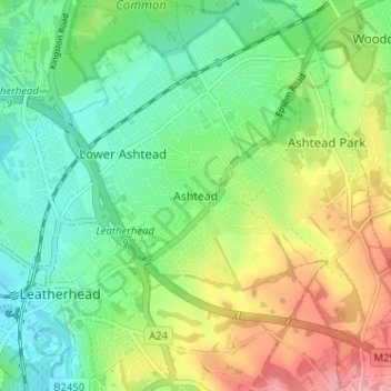
Name: Ashtead topographic map, elevation, terrain.
Average elevation: 75 m
Minimum elevation: 29 m
Maximum elevation: 154 m
Surrey trails, hiking, mountain biking, running and outdoor activities
Other topographic maps
Click on a map to view its topography, its elevation and its terrain.
Headley Heath
United Kingdom > England > Surrey > Mole Valley > Box Hill Village
Average elevation: 165 m