
Berkeley County topographic map
Interactive map
Click on the map to display elevation.
About this map
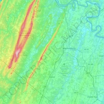
Name: Berkeley County topographic map, elevation, terrain.
Location: Berkeley County, West Virginia, United States (39.26448 -78.22991 39.62127 -77.82342)
Average elevation: 203 m
Minimum elevation: 95 m
Maximum elevation: 655 m
Other topographic maps
Click on a map to view its topography, its elevation and its terrain.
White Top
United States > West Virginia > Randolph County
White Top is a knob and spur of Cheat Mountain in southeastern Randolph County, West Virginia, USA. Sitting at an elevation of 4,085 feet (1,245 m), it is located just west of the Shavers Fork of Cheat River and Cheat Bridge. While White Top was originally crossed by the Staunton–Parkersburg Turnpike,…
Average elevation: 1,159 m
Spruce Knob
United States > West Virginia > Pendleton County
Spruce Mountain, located in eastern West Virginia, is the highest ridge of the Allegheny Mountains. The whale-backed ridge extends for only 16 miles (26 km) from northeast to southwest, but several of its peaks exceed 4,500 feet (1,400 m) in elevation. The summit, Spruce Knob (4,863 ft; 1,482 m), is the…
Average elevation: 1,274 m
Alderson Recreation Area
United States > West Virginia > Greenbrier County > Alderson
Average elevation: 501 m
Spruce Knob Lake
United States > West Virginia > Randolph County
Spruce Knob Lake is a 23-acre (0.093 km2) reservoir located within the Monongahela National Forest in Randolph County, West Virginia, USA. The recreation area surrounding Spruce Knob Lake contains camping and picnicking facilities as well as a boating site. At an elevation of 3,840 feet, it is the highest lake…
Average elevation: 1,204 m