
Kallu Kuttai Lake topographic map
Interactive map
Click on the map to display elevation.
About this map
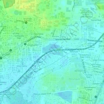
Name: Kallu Kuttai Lake topographic map, elevation, terrain.
Average elevation: 6 m
Minimum elevation: -4 m
Maximum elevation: 17 m
Other topographic maps
Click on a map to view its topography, its elevation and its terrain.
Chennai
India > Tamil Nadu > Chennai
Chennai is located on the south–eastern coast of India in the north–eastern part of Tamil Nadu on a flat coastal plain known as the Eastern Coastal Plains. Its average elevation is around 6.7 metres (22 ft), and its highest point is 60 m (200 ft). Chennai is 2,184 kilometres (1,357 mi) south of Delhi,…
Average elevation: 8 m
Chennai District
Chennai district covers an area of 426 km2 located on the Eastern Coastal Plains of India. It is situated on the northeastern corner of Tamil Nadu along the Coramandel coast, a region bounded by the Bay of Bengal and is surrounded inland by the districts of Tiruvallur, Kanchipuram and Chengalpattu. It lies…
Average elevation: 9 m
Hosur
India > Tamil Nadu > Hosur
Hosur experiences a tropical savanna climate (Köppen climate classification) with distinct wet and dry seasons. Due to its high elevation, Hosur usually enjoys salubrious and moderate climate throughout the year, with occasional heat waves. The coolest month is January with an average low temperature of 17.1…
Average elevation: 859 m
Mayiladuthurai
India > Tamil Nadu > Mayiladuthurai
Mayliladuthurai is situated at a distance of 281 kilometres (175 mi) from Chennai and 122 kilometres (76 mi) from Tiruchirappalli. The town is located at 11°06′N 79°39′E / 11.10°N 79.65°E / 11.10; 79.65. Situated at a distance of 24 kilometres (15 mi) from the Bay of Bengal coast, the town is…
Average elevation: 10 m
Arcot
India > Tamil Nadu > Arcot
Arcot is located at 12°54′N 79°20′E / 12.9°N 79.33°E / 12.9; 79.33. It has an average elevation of 164 metres (538 ft).
Average elevation: 169 m
Kalakkad Mundanthurai Tiger Reserve
India > Tamil Nadu > Ambasamudram
The reserve spans a range of 40 to 1,800 m in elevation. Agasthiyamalai (1681 m.) is in the core zone of the reserve.
Average elevation: 395 m
Kolukkumalai
India > Tamil Nadu > Bodinayakanur
Kolukkumalai is a small village/hamlet in Bodinayakanur Taluk in the Theni district of the Indian state of Tamil Nadu. It is home to the highest tea plantation in the world with the tea grown here possessing a special flavour and freshness because of the high altitude. It is located near Munnar in Idukki…
Average elevation: 1,726 m
Virudhachalam
India > Tamil Nadu > Virudhachalam
Virudhachalam is located at 11°30′N 79°20′E / 11.50°N 79.33°E / 11.50; 79.33. It has an average elevation of 45 m (148 ft).
Average elevation: 44 m
Valparai
India > Tamil Nadu > Valparai
Valparai is located at 10°22′N 76°58′E / 10.37°N 76.97°E / 10.37; 76.97. It is a mid-elevation hill station (Ootacamund is considerably higher) and has an average elevation of 3,914 feet (1,193 m). It is close to the border with Thrissur district of the Kerala state.
Average elevation: 1,127 m
Chengam
India > Tamil Nadu > Chengam
Chengam is located at 12°18′N 78°48′E / 12.3°N 78.8°E / 12.3; 78.8. It has an average elevation of 272 metres (892 feet). Chengam municipality is located on the Pondicherry – Thiruvannamalai – Bangalore route, at a distance of 34 km from Thiruvannamalai.
Average elevation: 276 m
Vaniyambadi
India > Tamil Nadu > Vaniyambadi
Vaniyambadi is located at 12.6872° N, 78.6303° E. It has an average elevation of 354 metres (1,161 ft) and lies in the Eastern Ghats region and on the banks of the Palar river. Yelagiri and Javadi Hills are located to the south of the town. By road Vaniyambadi is surrounded by Ambur and Tirupathur which are…
Average elevation: 371 m
Aravakurichi
India > Tamil Nadu > Aravakurichi
Aravakurichi is located at 10°46′N 77°55′E / 10.77°N 77.92°E / 10.77; 77.92. and has an average elevation of 174 m (571 ft). The town is located off the Varnasi - Kanyakumari National Highway 7 (India). The time zone is IST (UTC+5:30).
Average elevation: 171 m
Coimbatore District
Apart from the species common to the plains, wild elephants, wild boars leopards, tigers, bison, species of deer, Nilgiri tahr, sloth bear and black-headed oriole can be found. The Anamalai Wildlife Sanctuary 88 km (55 mi) in the Western Ghats at an altitude of 1,400 meters covers an area of 958 km2. More than…
Average elevation: 551 m
Thengapattinam
India > Tamil Nadu > Vilavancode
Thengapattanam is located in the South western coast of India bordering the Arabian Sea to the west, western ghats to the north, and vast fertile plains with intermittent Rocky hills to the east. The town is 11 km into the Tamil Nadu border from Kerala. The Kerala state capital Thiruvananthapuram is 45 km away…
Average elevation: 17 m