
Folkestone and Hythe District topographic map
Interactive map
Click on the map to display elevation.
About this map
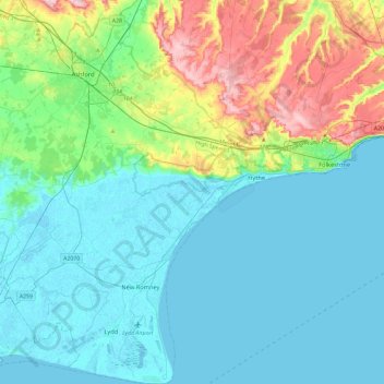
Name: Folkestone and Hythe District topographic map, elevation, terrain.
Location: Folkestone and Hythe District, Kent, England, United Kingdom (50.91048 0.77684 51.20501 1.22124)
Average elevation: 40 m
Minimum elevation: -2 m
Maximum elevation: 191 m
Kent trails, hiking, mountain biking, running and outdoor activities
Other topographic maps
Click on a map to view its topography, its elevation and its terrain.
White Cliffs of Dover
United Kingdom > England > Kent > Dover > St. Margaret's at Cliffe
Average elevation: 49 m
Holborough Lakes
United Kingdom > England > Kent > Tonbridge and Malling > Snodland
Average elevation: 32 m
Bedgebury National Pinetum
United Kingdom > England > Kent > Tunbridge Wells > Kilndown
Average elevation: 91 m
Ham Street Woods National Nature Reserve
United Kingdom > England > Kent > Ashford > Hamstreet
Average elevation: 31 m
Greatstone beach
United Kingdom > England > Kent > Folkestone and Hythe District > New Romney > Littlestone on Sea
Average elevation: 2 m
Oare Creek
United Kingdom > England > Kent > Borough of Swale > Faversham > Oare
Average elevation: 6 m
Park Gate
United Kingdom > England > Kent > Folkestone and Hythe District > Elham
Average elevation: 130 m
Rusthall Common Cricket Ground
United Kingdom > England > Kent > Tunbridge Wells > Rusthall
Average elevation: 99 m
Chalybeate Spring
United Kingdom > England > Kent > Tunbridge Wells > Kilndown
Average elevation: 65 m