
Labrador topographic map
Interactive map
Click on the map to display elevation.
About this map
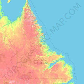
Name: Labrador topographic map, elevation, terrain.
Location: Labrador, Newfoundland and Labrador, Canada (51.34592 -67.82169 60.47703 -55.20510)
Average elevation: 222 m
Minimum elevation: -1 m
Maximum elevation: 1,457 m
Other topographic maps
Click on a map to view its topography, its elevation and its terrain.
Pee Pee Island
Canada > Newfoundland and Labrador > unincorporated Newfoundland
Average elevation: 16 m
Fogo Island
Canada > Newfoundland and Labrador > Joe Batt's Arm-Barr'd Islands-Shoal Bay
Average elevation: 3 m