
Hlegu topographic map
Interactive map
Click on the map to display elevation.
About this map
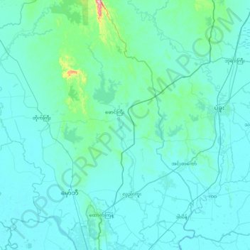
Name: Hlegu topographic map, elevation, terrain.
Location: Hlegu, Yangon North, Yangon, Myanmar (16.94182 96.02813 17.64102 96.40770)
Average elevation: 26 m
Minimum elevation: -1 m
Maximum elevation: 465 m
Other topographic maps
Click on a map to view its topography, its elevation and its terrain.
Yangon River
Yangon River, Hlaing, Northern District, Yangon, 11047, Myanmar
Average elevation: 6 m
Yakhine Gyaung
Myanmar > Yangon > Yangon > Yakhine Gyaung
Yakhine Gyaung, Southern District, Yangon, Myanmar
Average elevation: 4 m
Kandawgyi Lake
Kandawgyi Lake, Kan Yeiktha Road, Mingala Taungnyunt, Western District, Yangon, 00000, Myanmar
Average elevation: 22 m