
Tuscany topographic map
Click on the map to display elevation.
About this map
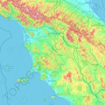
Name: Tuscany topographic map, elevation, terrain.
Location: Tuscany, Italy (42.23762 9.68677 44.47254 12.37227)
Average elevation: 267 m
Minimum elevation: -5 m
Maximum elevation: 2,029 m
Other topographic maps
Click on a map to view its topography, its elevation and its terrain.
Matterhorn
Italy > Aosta Valley > Valtournenche
In 1999, the summit height was precisely determined to be at 4,477.54 m (14,690 ft) above sea level by using Global Positioning System technology as part of the TOWER Project (Top of the World Elevations Remeasurement) and to an accuracy of less than one centimetre, which allows future changes to be tracked.
Average elevation: 3,295 m
Mottarone
Italy > Piedmont > Verbano-Cusio-Ossola > Stresa
Mottarone is a mountain in the Western Alps of Piedmont, north-western Italy, with an elevation of 1,492 metres (4,895 ft). It is located between the provinces of Verbano-Cusio-Ossola and Novara.
Average elevation: 1,177 m
Mount Etna
During the first 1500 years AD, many eruptions went unrecorded (or records have been lost); among the more significant are: (1) an eruption in about 1030 AD near Monte Ilice on the lower southeast flank, which produced a lava flow that travelled about 10 km, reaching the sea north of Acireale; the villages of…
Average elevation: 1,157 m
Apennine Mountains
A separate branch, the Apuan Alps, goes southwest, bordering the coast south of La Spezia. Whether they are to be considered part of the Apennines is a matter of opinion; certainly, they are part of the Apennine System. Topographically only the valley of the River Serchio, which running parallel to the coast…
Average elevation: 1,735 m
Mount Vesuvius
Italy > Campania > Naples > Trecase
The volcano's slopes are scarred by lava flows, while the rest are heavily vegetated, with scrub and forests at higher altitudes and vineyards lower down.
Average elevation: 862 m
Le Breuil - Cervinia
The ski area is very large and guarantees good snow quality during the season, being at a high altitude (2,050 m to 3,500 m).
Average elevation: 2,376 m
Valle / Val
Italy > Friuli – Venezia Giulia > Pordenone / Pordenon > Colle / Cuel
Average elevation: 214 m
Remlau
Italy > Trentino – Alto Adige/Südtirol > South Tyrol > Ratschings - Racines > Mareit - Mareta
Average elevation: 1,334 m
Rome
Italy > Lazio > Roma Capitale
Although the city centre is about 24 km (15 mi) inland from the Tyrrhenian Sea, the city territory extends to the shore, where the south-western district of Ostia is located. The altitude of the central part of Rome ranges from 13 m (43 ft) above sea level (at the base of the Pantheon) to 139 m (456 ft) above…
Average elevation: 78 m
Cortina
Italy > Trentino – Alto Adige/Südtirol > Provincia di Trento > Vermiglio
Average elevation: 1,534 m
St. Valentin - S. Valentino
Italy > Trentino – Alto Adige/Südtirol > South Tyrol > Kastelruth - Castelrotto > Seis am Schlern - Siusi allo Sciliar
Average elevation: 1,237 m
Antrogna
Italy > Piedmont > Verbano-Cusio-Ossola > Calasca-Castiglione > Calasca
Average elevation: 979 m
Santo Stefano
Italy > Friuli – Venezia Giulia > Udine / Udin / Videm > Chiaicis
Average elevation: 481 m
Naples
Italy > Campania > Napoli > Naples
The city is situated on the Gulf of Naples, on the western coast of southern Italy; it rises from sea level to an elevation of 450 metres (1,480 ft). The small rivers which formerly crossed the centre of the city have since been covered over by construction. It lies between two notable volcanic regions, Mount…
Average elevation: 58 m
Parco Generale Carlo Alberto Dalla Chiesa
Italy > Piedmont > Turin > Collegno
Average elevation: 297 m
Rumestluns
Italy > Trentino – Alto Adige/Südtirol > South Tyrol > La Val - Wengen - La Valle
Average elevation: 1,726 m
Gaglietole
Italy > Umbria > Perugia > Collazzone
Gaglietole is a frazione of the comune of Collazzone in the Province of Perugia, Umbria, central Italy. It stands at an elevation of 326 metres above sea level. At the time of the Istat census of 2001 it had 76 inhabitants.
Average elevation: 305 m
Campo Carlo Magno
Italy > Trentino – Alto Adige/Südtirol > Provincia di Trento > Pinzolo > Madonna di Campiglio
Average elevation: 1,777 m
Gherdëina - Grödnertal - Val Gardena
Italy > Trentino – Alto Adige/Südtirol > South Tyrol > Urtijëi - St. Ulrich in Gröden - Ortisei
Average elevation: 1,607 m
Masl
Italy > Trentino – Alto Adige/Südtirol > South Tyrol > Mühlbach - Rio di Pusteria > Vals - Valles
Average elevation: 1,661 m
Gradischiutta / Radišče / Gradiscjute
Italy > Friuli – Venezia Giulia > Udine / Udin / Videm > Faedis / Fojda > Clap / Podrata
Average elevation: 540 m
Lari
Lari is a walled mountaintop frazione, or hamlet, in the comune of Casciana Terme Lari, 60 kilometres (37 mi) southwest of Florence and 25 kilometres (16 mi) southeast of Pisa, in the Tuscany region of Italy. The municipal seat of its comune, Lari dates from at least the 9th century BC, a fact established by…
Average elevation: 80 m
Monte Cassino
Italy > Lazio > Frosinone > Cassino
Monte Cassino (today usually spelled Montecassino) is a rocky hill about 130 kilometres (80 mi) southeast of Rome, in the Latin Valley, Italy, 2 kilometres (1+1⁄4 mi) west of Cassino and at an elevation of 520 m (1,710 ft). Site of the Roman town of Casinum, it is widely known for its abbey, the first house…
Average elevation: 231 m
Monte Cornetto
Italy > Trentino – Alto Adige/Südtirol > Provincia di Trento > Trento
Average elevation: 1,659 m
Castelleone
Italy > Umbria > Perugia > Deruta
Castelleone is a frazione of the comune of Deruta in the Province of Perugia, Umbria, central Italy. It stands at an elevation of 398 metres above sea level. At the time of the Istat census of 2001 it had 91 inhabitants.
Average elevation: 346 m
Lothen - Campolino
Italy > Trentino – Alto Adige/Südtirol > South Tyrol > St. Lorenzen - San Lorenzo di Sebato > Pflaurenz - Floronzo
Average elevation: 930 m