
Make a donation
Gear up for your next adventure:
As an Amazon Associate, this site earns from qualifying purchases at no extra cost to you.
Ditchling topographic map
Click on the map to display elevation.
Gear up for your next adventure:
As an Amazon Associate, this site earns from qualifying purchases at no extra cost to you.
About this map
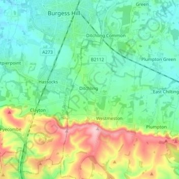
Name: Ditchling topographic map, elevation, terrain.
Location: Ditchling, Lewes, East Sussex, England, United Kingdom (50.87722 -0.13587 50.96365 -0.08734)
Average elevation: 84 m
Minimum elevation: 19 m
Maximum elevation: 252 m
East Sussex trails, hiking, mountain biking, running and outdoor activities
Make a donation
Gear up for your next adventure:
As an Amazon Associate, this site earns from qualifying purchases at no extra cost to you.
Other topographic maps
Click on a map to view its topography, its elevation and its terrain.
Make a donation
Gear up for your next adventure:
As an Amazon Associate, this site earns from qualifying purchases at no extra cost to you.
Make a donation
Gear up for your next adventure:
As an Amazon Associate, this site earns from qualifying purchases at no extra cost to you.
South Heighton
United Kingdom > England > East Sussex > Lewes > South Heighton
Average elevation: 37 m
Kingston Near Lewes
United Kingdom > England > East Sussex > Lewes > Kingston Near Lewes
Average elevation: 65 m