Geolocate

Broyle Side topographic map

Click on the map to display elevation.

About this map

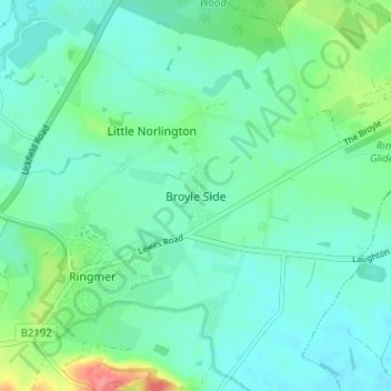
Name: Broyle Side topographic map, elevation, terrain.

Location: Broyle Side, Lewes, East Sussex, England, BN8 5PA, United Kingdom (50.88123 0.05455 50.92123 0.09455)

Average elevation: 19 m

Minimum elevation: 1 m

Maximum elevation: 79 m

East Sussex trails, hiking, mountain biking, running and outdoor activities

Other topographic maps

Click on a map to view its topography, its elevation and its terrain.

Ditchling

United Kingdom > England > East Sussex > Lewes

Average elevation: 84 m

South Heighton

United Kingdom > England > East Sussex > Lewes

Average elevation: 72 m

Westmeston

United Kingdom > England > East Sussex > Lewes

Average elevation: 80 m

Falmer

United Kingdom > England > East Sussex > Lewes

Average elevation: 116 m

Chailey

United Kingdom > England > East Sussex > Lewes

Average elevation: 40 m

Plumpton

United Kingdom > England > East Sussex > Lewes

Average elevation: 71 m

Streat

United Kingdom > England > East Sussex > Lewes

Average elevation: 78 m

Newick

United Kingdom > England > East Sussex > Lewes

Average elevation: 32 m

Telscombe

United Kingdom > England > East Sussex > Lewes

Average elevation: 55 m

Piddinghoe

United Kingdom > England > East Sussex > Lewes > Piddinghoe

Average elevation: 27 m

Barcombe

United Kingdom > England > East Sussex > Lewes

Average elevation: 22 m

Hamsey

United Kingdom > England > East Sussex > Lewes > Cooksbridge

Average elevation: 34 m

Telscombe

United Kingdom > England > East Sussex > Lewes

Average elevation: 55 m

Telscombe

United Kingdom > England > East Sussex > Lewes > Telscombe

Average elevation: 55 m

Seaford

United Kingdom > England > East Sussex > Lewes

Average elevation: 28 m

Plumpton

United Kingdom > England > East Sussex > Lewes

Average elevation: 71 m

Telscombe

United Kingdom > England > East Sussex > Lewes > Telscombe

Average elevation: 55 m

Falmer

United Kingdom > England > East Sussex > Lewes > Falmer

Average elevation: 116 m

Gear up for your next adventure:

🧥Waterproof Hiking Jackets - Rain protection for walking in all weather conditions
📻Hand-Crank Emergency Radios - Stay updated on weather warnings in remote areas
🧷Tenacious Repair Tape - Instant fix for torn tents, jackets, or dry bags
🧴Sport Sunscreen Sticks - High-protection sunblock that won't run into your eyes on the trail
📱Phone Mounts for Hiking - Secure mounts to carry your phone on trails

As an Amazon Associate, this site earns from qualifying purchases at no extra cost to you.