
Piddinghoe topographic map
Interactive map
Click on the map to display elevation.
About this map
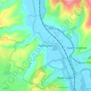
Name: Piddinghoe topographic map, elevation, terrain.
Location: Piddinghoe, Lewes, East Sussex, England, BN9 9AR, United Kingdom (50.78876 0.01501 50.82876 0.05501)
Average elevation: 33 m
Minimum elevation: -3 m
Maximum elevation: 138 m
East Sussex trails, hiking, mountain biking, running and outdoor activities
Other topographic maps
Click on a map to view its topography, its elevation and its terrain.
Kingston Near Lewes
United Kingdom > England > East Sussex > Lewes > Kingston Near Lewes
Average elevation: 65 m