
Tsumeb topographic map
Interactive map
Click on the map to display elevation.
About this map
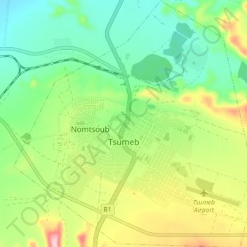
Name: Tsumeb topographic map, elevation, terrain.
Location: Tsumeb, Oshikoto, Namibia (-19.27501 17.67941 -19.21294 17.74380)
Average elevation: 1,310 m
Minimum elevation: 1,234 m
Maximum elevation: 1,447 m
Near to the town are two large sinkhole lakes, Lake Otjikoto and Lake Guinas ("Gwee-nus"). Guinas, at about 500 m in diameter, is somewhat larger in area than Otjikoto. A pioneering documentary movie about scuba diving in these lakes was made by Graham Ferreira in the early 1970s. The depths of the lakes are unknown, because towards the bottom both lakes disappear into lateral cave systems, so it is not possible to use a weight to sound them. Otjikoto, which has poor visibility (owing to pollution from agricultural fertilizers used nearby), is at least 60 m deep. The water in Guinas is completely clear and well over 100 m deep. Divers who have performed bounce-dives in Guinas to 80 m (strictly speaking, beyond the safe depth for such dives, especially given the altitude of the lake above sealevel) have reported that there was nothing but powdery-blue water below them. Guinas has been in existence for so long that a unique species of fish, Tilapia guinasana, has evolved in its waters.
Other topographic maps
Click on a map to view its topography, its elevation and its terrain.
Helio (man-made water point)
Helio (man-made water point), Oshikoto, Namibia
Average elevation: 1,109 m