
Make a donation
Gear up for your next adventure:
As an Amazon Associate, this site earns from qualifying purchases at no extra cost to you.
Wasilla topographic map
Click on the map to display elevation.
Make a donation
Gear up for your next adventure:
As an Amazon Associate, this site earns from qualifying purchases at no extra cost to you.
About this map
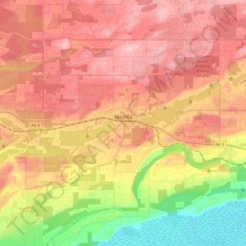
Name: Wasilla topographic map, elevation, terrain.
Location: Wasilla, Matanuska-Susitna Borough, Alaska, United States (61.55290 -149.56469 61.60653 -149.35364)
Average elevation: 98 m
Minimum elevation: 2 m
Maximum elevation: 166 m
Make a donation
Gear up for your next adventure:
As an Amazon Associate, this site earns from qualifying purchases at no extra cost to you.
Other topographic maps
Click on a map to view its topography, its elevation and its terrain.
Willow
United States > Alaska > Matanuska-Susitna Borough
Willow has a subarctic climate with long and cold winters and mild summers. Whites Crossing is a weather station near Willow, situated at an elevation of 270 ft (82 m).
Average elevation: 69 m
Make a donation
Gear up for your next adventure:
As an Amazon Associate, this site earns from qualifying purchases at no extra cost to you.
Make a donation
Gear up for your next adventure:
As an Amazon Associate, this site earns from qualifying purchases at no extra cost to you.
Denali State Park
United States > Alaska > Matanuska-Susitna Borough
Denali State Park is in sight of Denali, the highest mountain peak in North America, with a summit elevation of 20,310 feet above sea level. Denali rises 18,000 feet from base to peak, making it the largest mountain situated entirely above sea level. To the east, the state park borders the Susitna River, which…
Average elevation: 702 m
Make a donation
Gear up for your next adventure:
As an Amazon Associate, this site earns from qualifying purchases at no extra cost to you.