Geolocate

London topographic map

Interactive map

Click on the map to display elevation.

About this map

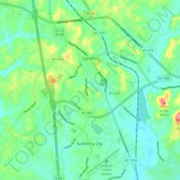
Name: London topographic map, elevation, terrain.

Location: London, Laurel County, Kentucky, 40741, United States (37.07976 -84.12626 37.15226 -84.03596)

Average elevation: 370 m

Minimum elevation: 338 m

Maximum elevation: 462 m

London is located in central Laurel County at 37°7′39″N 84°5′3″W / 37.12750°N 84.08417°W / 37.12750; -84.08417 (37.127504, -84.084181) and at an elevation of 1,240 feet (380 m).

Wikipedia (CC-BY-SA 3.0)

Other topographic maps

Click on a map to view its topography, its elevation and its terrain.

Hopewell

United States > Kentucky > Laurel County

Hopewell, Laurel County, Kentucky, 40737, United States

Average elevation: 358 m

Lily

United States > Kentucky > Laurel County

Lily, Laurel County, Kentucky, 40740, United States

Average elevation: 350 m

Keavy

United States > Kentucky > Laurel County > Keavy

Keavy, Laurel County, Kentucky, 40737, United States

Average elevation: 363 m

Cane Creek

United States > Kentucky > Laurel County > Cane Creek

Cane Creek, Laurel County, Kentucky, United States

Average elevation: 377 m