
Make a donation
Gear up for your next adventure:
As an Amazon Associate, this site earns from qualifying purchases at no extra cost to you.
Lily topographic map
Click on the map to display elevation.
Make a donation
Gear up for your next adventure:
As an Amazon Associate, this site earns from qualifying purchases at no extra cost to you.
About this map
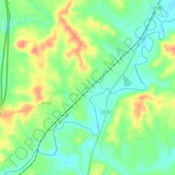
Name: Lily topographic map, elevation, terrain.
Location: Lily, Laurel County, Kentucky, 40740, United States (37.00459 -84.09489 37.04459 -84.05489)
Average elevation: 350 m
Minimum elevation: 325 m
Maximum elevation: 389 m
Make a donation
Gear up for your next adventure:
As an Amazon Associate, this site earns from qualifying purchases at no extra cost to you.
Other topographic maps
Click on a map to view its topography, its elevation and its terrain.
London
United States > Kentucky > Laurel County
London is located in central Laurel County at 37°7′39″N 84°5′3″W / 37.12750°N 84.08417°W / 37.12750; -84.08417 (37.127504, -84.084181) and at an elevation of 1,240 feet (380 m).
Average elevation: 370 m
Make a donation
Gear up for your next adventure:
As an Amazon Associate, this site earns from qualifying purchases at no extra cost to you.