Geolocate

Pinal County topographic map

Interactive map

Click on the map to display elevation.

About this map

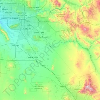
Name: Pinal County topographic map, elevation, terrain.

Location: Pinal County, Arizona, United States (32.50123 -112.20374 33.46610 -110.44847)

Average elevation: 729 m

Minimum elevation: 287 m

Maximum elevation: 2,782 m

Other topographic maps

Click on a map to view its topography, its elevation and its terrain.

Scottsdale

United States > Arizona > Maricopa County > Scottsdale

The city is in the Salt River Valley, or the "Valley of the Sun," in the northern reaches of the Sonoran Desert. Scottsdale, 31 mi (50 km) long and 11.4 mi (18.3 km) wide at its widest point, shares boundaries with many other municipalities and entities. On the west, Scottsdale is bordered by Phoenix, Paradise…

Average elevation: 414 m

Yuma

United States > Arizona > Yuma County

Average elevation: 69 m

Vail

United States > Arizona > Pima County > Vail

Average elevation: 1,035 m

Grand Canyon

United States > Arizona > Coconino County

Uplift associated with mountain formation later moved these sediments thousands of feet upward and created the Colorado Plateau. The higher elevation has also resulted in greater precipitation in the Colorado River drainage area, but not enough to change the Grand Canyon area from being semi-arid. The uplift…

Average elevation: 1,023 m

Hoover Dam

United States > Arizona > Mohave County

The amount of electricity generated by Hoover Dam has been decreasing along with the falling water level in Lake Mead due to the prolonged drought since year 2000 and high demand for the Colorado River's water. By 2014 its generating capacity was downrated by 23% to 1592 MW and was providing power only during…

Average elevation: 429 m

Green Valley

United States > Arizona > Pima County > Sahuarita

Average elevation: 962 m

Spider Rock

United States > Arizona > Apache County

Average elevation: 1,954 m

Portal

United States > Arizona > Cochise County

Average elevation: 1,523 m

Bear Canyon Lake

United States > Arizona > Coconino County

Average elevation: 2,349 m

Grand Canyon

United States > Arizona > Coconino County

Uplift associated with mountain formation later moved these sediments thousands of feet upward and created the Colorado Plateau. The higher elevation has also resulted in greater precipitation in the Colorado River drainage area, but not enough to change the Grand Canyon area from being semi-arid. The uplift…

Average elevation: 1,023 m

Wilhoit

United States > Arizona > Yavapai County

Average elevation: 1,416 m

Saddlebrooke

United States > Arizona > Pinal County

Average elevation: 1,029 m

Indian Gardens

United States > Arizona > Coconino County

Average elevation: 1,694 m

Concho

United States > Arizona > Apache County

Average elevation: 1,844 m

Valle Vista

United States > Arizona > Mohave County

Average elevation: 991 m

Fort McDowell

United States > Arizona > Maricopa County

Average elevation: 447 m

Mogollon Rim

United States > Arizona > Coconino County

Average elevation: 1,990 m

Wild Horse Mesa

United States > Arizona > Coconino County

Average elevation: 1,284 m

Topock

United States > Arizona > Mohave County

Average elevation: 180 m

Packer (Site)

United States > Arizona > Yavapai County

Average elevation: 1,328 m

Long Valley

United States > Arizona > Coconino County

Average elevation: 2,156 m

Fortuna Foothills

United States > Arizona > Yuma County

Average elevation: 113 m

Windy Point

United States > Arizona > Pima County

Average elevation: 1,847 m

Marcou Mesa

United States > Arizona > Navajo County

Average elevation: 1,709 m

Grand Canyon

United States > Arizona > Coconino County

Uplift associated with mountain formation later moved these sediments thousands of feet upward and created the Colorado Plateau. The higher elevation has also resulted in greater precipitation in the Colorado River drainage area, but not enough to change the Grand Canyon area from being semi-arid. The uplift…

Average elevation: 1,023 m

Lake Montezuma

United States > Arizona > Yavapai County > Rimrock

Average elevation: 1,084 m

East Mesa

United States > Arizona > Apache County

Average elevation: 2,093 m

Roden Crater

United States > Arizona > Coconino County

Average elevation: 1,497 m

Greenback Peak

United States > Arizona > Gila County

Average elevation: 1,680 m

Roll

United States > Arizona > Yuma County

Average elevation: 80 m

Iron Springs

United States > Arizona > Yavapai County

Average elevation: 1,828 m

Willow Beach

United States > Arizona > Mohave County

Average elevation: 321 m

Portal

United States > Arizona > Cochise County

Average elevation: 1,523 m

Benton Tank

United States > Arizona > Greenlee County

Average elevation: 1,701 m

Lizard Rock

United States > Arizona > Pima County

Average elevation: 2,041 m

Corona de Tucson

United States > Arizona > Pima County

Average elevation: 1,027 m

Fort Mohave

United States > Arizona > Mohave County

Average elevation: 183 m

Continental

United States > Arizona > Pima County > Green Valley

Average elevation: 888 m

Crystal Beach

United States > Arizona > Mohave County

Average elevation: 172 m

Pascua Pueblo

United States > Arizona > Pima County

Average elevation: 793 m

Vail

United States > Arizona > Pima County > Vail

Average elevation: 1,035 m

Mobile

United States > Arizona > Maricopa County > Goodyear

Average elevation: 402 m

Havasupai Gardens

United States > Arizona > Coconino County

Average elevation: 1,333 m

Thumb

United States > Arizona > Mohave County

Average elevation: 1,160 m

Monument Valley

United States > Arizona > Navajo County

The area is part of the Colorado Plateau. The elevation of the valley floor ranges from 5,000 to 6,000 feet (1,500 to 1,800 m) above sea level. The floor is largely siltstone of the Cutler Group, or sand derived from it, deposited by the meandering rivers that carved the valley. The valley's vivid red color…

Average elevation: 1,675 m

Sunset Crater

United States > Arizona > Coconino County

Average elevation: 2,168 m

Marble Canyon

United States > Arizona > Coconino County

Average elevation: 1,102 m

Dateland

United States > Arizona > Yuma County

Average elevation: 134 m

Heber-Overgaard

United States > Arizona > Navajo County

Heber-Overgaard is a census-designated place (CDP) in Navajo County, Arizona, United States. Situated atop the Mogollon Rim, the community lies at an elevation of 6,627 feet (2,020 m). The population was 2,898 at the 2020 census. Heber and Overgaard are technically two unincorporated communities, but as of the…

Average elevation: 2,015 m

River Island

United States > Arizona > Mohave County

Average elevation: 459 m

Whetstone

United States > Arizona > Cochise County > Whetstone

Average elevation: 1,338 m

Wilhoit

United States > Arizona > Yavapai County

Average elevation: 1,520 m

Audley

United States > Arizona > Yavapai County

Average elevation: 1,589 m

San Tan Valley

United States > Arizona > Pinal County

Average elevation: 463 m

Golden Valley

United States > Arizona > Mohave County

Average elevation: 864 m

Rocky Point

United States > Arizona > Maricopa County

Average elevation: 396 m

Woods Canyon Lake

United States > Arizona > Coconino County

Average elevation: 2,321 m

Dude Mountain

United States > Arizona > Coconino County > Williams

Average elevation: 2,146 m

Sun Valley

United States > Arizona > Navajo County

Average elevation: 1,615 m

El Mirage

United States > Arizona > Maricopa County

Average elevation: 352 m

Saddlebrooke

United States > Arizona > Pinal County

Average elevation: 1,029 m

Peeples Valley

United States > Arizona > Yavapai County

Average elevation: 1,472 m

Skull Valley

United States > Arizona > Yavapai County

Average elevation: 1,342 m

Le Fevre Overlook

United States > Arizona > Coconino County

Average elevation: 2,032 m

Yaki Point

United States > Arizona > Coconino County

Average elevation: 1,774 m

Three Sisters

United States > Arizona > Navajo County

The area is part of the Colorado Plateau. The elevation of the valley floor ranges from 5,000 to 6,000 feet (1,500 to 1,800 m) above sea level. The floor is largely siltstone of the Cutler Group, or sand derived from it, deposited by the meandering rivers that carved the valley. The valley's vivid red color…

Average elevation: 1,664 m

Antelope Canyon

United States > Arizona > Coconino County

Average elevation: 1,205 m

Michigan Lake

United States > Arizona > Apache County

Average elevation: 1,888 m

Waddell

United States > Arizona > Maricopa County

Average elevation: 369 m

Heber-Overgaard

United States > Arizona > Navajo County

Heber-Overgaard is a census-designated place (CDP) in Navajo County, Arizona, United States. Situated atop the Mogollon Rim, the community lies at an elevation of 6,627 feet (2,020 m). The population was 2,898 at the 2020 census. Heber and Overgaard are technically two unincorporated communities, but as of the…

Average elevation: 2,015 m

Red Rock

United States > Arizona > Apache County

Average elevation: 1,780 m

Hualapai Peak

United States > Arizona > Mohave County

Average elevation: 2,230 m

Mather Point

United States > Arizona > Coconino County

Average elevation: 1,800 m

Green Valley

United States > Arizona > Pima County

Average elevation: 914 m

Quartzsite

United States > Arizona > La Paz County

Average elevation: 288 m

Elgin

United States > Arizona > Santa Cruz County

Average elevation: 1,484 m

Sawmill

United States > Arizona > Apache County

Average elevation: 2,354 m

Kelvin

United States > Arizona > Pinal County

Average elevation: 626 m

Glen Oaks

United States > Arizona > Yavapai County

Average elevation: 1,717 m

Ajo

United States > Arizona > Pima County

Average elevation: 547 m

St. Johns

United States > Arizona > Maricopa County > Komatke

Average elevation: 310 m

White Mountain

United States > Arizona > Gila County

Average elevation: 1,363 m

Phantom Ranch

United States > Arizona > Coconino County

Average elevation: 1,013 m

Ash Fork

United States > Arizona > Yavapai County

Average elevation: 1,561 m

White Tank

United States > Arizona > Gila County

Average elevation: 1,298 m

Willcox

United States > Arizona > Cochise County

Willcox's high elevation gives it a milder climate than the nearby Valley of the Sun and Sonoran Desert. It also receives more rainfall than Tucson and Phoenix due to the summer monsoon rains and thus it has a hot semi-arid climate (Koppen: BSh).

Average elevation: 1,274 m

Tyson

United States > Arizona > Yuma County

Average elevation: 94 m

Lakeside

United States > Arizona > Navajo County > Pinetop-Lakeside

Average elevation: 2,059 m

Bryce

United States > Arizona > Graham County

Average elevation: 876 m

Willcox

United States > Arizona > Cochise County

Willcox's high elevation gives it a milder climate than the nearby Valley of the Sun and Sonoran Desert. It also receives more rainfall than Tucson and Phoenix due to the summer monsoon rains and thus it has a hot semi-arid climate (Koppen: BSh)

Average elevation: 1,274 m

Bakerville

United States > Arizona > Cochise County > Bisbee > Warren

Bakerville is a populated place situated within the city of Bisbee in Cochise County, Arizona, United States. It has an estimated elevation of 5,039 feet (1,536 m) above sea level.

Average elevation: 1,579 m

New River Mesa

United States > Arizona > Maricopa County

Average elevation: 1,199 m

Tempe

United States > Arizona > Maricopa County > Tempe

Tempe is generally flat, except for Hayden Butte (generally known as A-Mountain for Arizona State University's "A" logo located on its south face), located next to Sun Devil Stadium, Twin Buttes and Bell Butte on the western edge of Tempe, and Papago Park northwest of Tempe, inside Phoenix. Elevation ranges…

Average elevation: 386 m