
Yantai topographic map
Interactive map
Click on the map to display elevation.
About this map
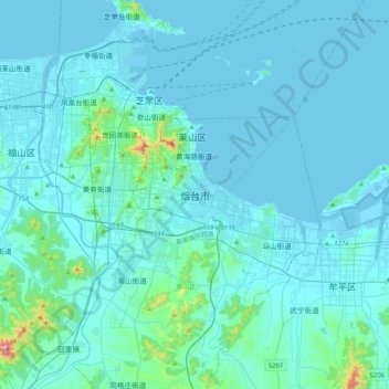
Name: Yantai topographic map, elevation, terrain.
Average elevation: 34 m
Minimum elevation: -3 m
Maximum elevation: 546 m
Yantai is located along the north coast of the Shandong Peninsula, south of the junction of Bohai Sea and Yellow Sea and parallel to the southern coast of Liaoning. The topographical breakdown consists of:
Other topographic maps
Click on a map to view its topography, its elevation and its terrain.