
Fresno topographic map
Interactive map
Click on the map to display elevation.
About this map
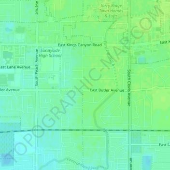
Name: Fresno topographic map, elevation, terrain.
Location: Fresno, Fresno County, California, United States (36.72845 -119.70935 36.73044 -119.70836)
Average elevation: 98 m
Minimum elevation: 92 m
Maximum elevation: 102 m
Other topographic maps
Click on a map to view its topography, its elevation and its terrain.
Kings Canyon National Park
United States > California > Fresno County
Kings Canyon is characterized by some of the steepest vertical relief in North America, with numerous peaks over 14,000 feet (4,300 m) on the Sierra Crest along the park's eastern border, falling to 4,500 feet (1,400 m) in the valley floor of Cedar Grove just ten miles (16 km) to the west. The Sierran crest…
Average elevation: 2,591 m
Sanger
United States > California > Fresno County
Sanger is a city in Fresno County, California, United States. The population was 26,617 at the 2020 census, up from 26,617 at the 2020 census and 18,731 at the 2000 census. Sanger is located 13 miles (21 km) east-southeast of Fresno, at an elevation of 371 feet (113 m).
Average elevation: 111 m
Clovis
United States > California > Fresno County
In the 2020 census, the population was 120,124. Clovis is located 6.5 miles (10.5 km) northeast of downtown Fresno, at an elevation of 361 feet (110 m).
Average elevation: 127 m
Fowler
United States > California > Fresno County
Fowler (formerly, Fowler's Switch) is a city in Fresno County, California, United States. It is located within the San Joaquin Valley. It has a strong agricultural community, with lush grape vineyards and expansive farmland. Fowler is located 11 miles (18 km) southeast of downtown Fresno, at an elevation of…
Average elevation: 94 m
Clovis
United States > California > Fresno County
Clovis is a city in Fresno County, California, United States. The 2020 population was 120,124. Clovis is located 6.5 miles (10.5 km) northeast of downtown Fresno, at an elevation of 361 feet (110 m).
Average elevation: 127 m
Leaky Acres Groundwater Recharge Basin
United States > California > Fresno County > Fresno
Average elevation: 103 m
Yokuts Valley
United States > California > Fresno County
As of the 2010 census, the CDP had a total population of 3,162, up from 2,691 at the 2000 census. For statistical purposes, the United States Census Bureau defined Squaw Valley as a census-designated place (CDP). Yokuts Valley is located 9 miles (14 km) north-northeast of Orange Cove and 30 miles (48 km) east…
Average elevation: 550 m
Auberry
United States > California > Fresno County > New Auberry
Auberry (/ˈɔːbɛri/) is a census-designated place (CDP) in Fresno County, California, United States. The population was 2,369 at the 2010 census, up from 2,053 at the 2000 census. Auberry is located on Little Sandy Creek 9.5 miles (15 km) west of Shaver Lake Heights, at an elevation of 2,018 feet (615 m).
Average elevation: 611 m
Orange Cove
United States > California > Fresno County
Almost all of Orange Cove's residents are Hispanic, many of them farmers. Orange Cove is located in the San Joaquin Valley, 8 miles (13 km) east-northeast of Reedley, at an elevation of 423 feet (129 m).
Average elevation: 132 m
Selma
United States > California > Fresno County
Selma is a city in Fresno County, California. The population was 23,319 at the 2010 census, up from 19,240 at the 2000 census. Selma is located 16 miles (26 km) southeast of Fresno, at an elevation of 308 feet (94 m).
Average elevation: 96 m
Hume Lake
United States > California > Fresno County > Hume
The surface elevation of the lake is 1,586.34 m (5,204.5 ft). It is accessible from California Route 180, via Forest Service road 30, and is about 51 mi (82 km) east of Fresno, not far from the west entrance to Kings Canyon National Park.
Average elevation: 1,661 m
Yokuts Valley
United States > California > Fresno County
As of the 2010 census, the CDP had a total population of 3,162, up from 2,691 at the 2000 census. Yokuts Valley is located 9 miles (14 km) north-northeast of Orange Cove and 30 miles (48 km) east of Fresno, at an elevation of 1,631 ft (497 m).
Average elevation: 437 m
Sanger
United States > California > Fresno County
Sanger is a city in Fresno County, California, United States. The population was 26,617 at the 2020 census, up from 24,270 at the 2010 census and 18,731 at the 2000 census. Sanger is located 13 miles (21 km) east-southeast of Fresno, at an elevation of 371 feet (113 m).
Average elevation: 111 m
Reedley
United States > California > Fresno County
Reedley is a city in Fresno County, California, United States. It is located in the San Joaquin Valley, 22 miles (35 km) east-southeast of Fresno, at an elevation of 348 feet (106 m). The population at the 2010 census was 24,194. Its chief economic source is agriculture, particularly fruit and vegetable…
Average elevation: 110 m
Auberry
United States > California > Fresno County > New Auberry
Auberry (/ˈɔːbɛri/) is a census-designated place (CDP) in Fresno County, California, United States. The population was 2,369 at the 2010 census, up from 2,053 at the 2000 census. Auberry is located on Little Sandy Creek 9.5 miles (15 km) west of Shaver Lake Heights, at an elevation of 2,018 feet (615 m).
Average elevation: 611 m
Kings Canyon National Park
United States > California > Fresno County
Kings Canyon is characterized by some of the steepest vertical relief in North America, with numerous peaks over 14,000 feet (4,300 m) on the Sierra Crest along the park's eastern border, falling to 4,500 feet (1,400 m) in the valley floor of Cedar Grove just ten miles (16 km) to the west. The Sierran crest…
Average elevation: 2,591 m
Clovis
United States > California > Fresno County
Clovis is a city in Fresno County, California, United States. The 2020 population was 120,124. Clovis is located 6.5 miles (10.5 km) northeast of downtown Fresno, at an elevation of 361 feet (110 m).
Average elevation: 127 m
Coalinga
United States > California > Fresno County
Coalinga is located 52 miles (84 km) southwest of Fresno, at an elevation of 673 feet (205 m). The topography is generally level, suitable for a number of field crops which do not require large amounts of water. It is located in the Pleasant Valley, east of the Alcalde Hills, north of the Jacalitos Hills,…
Average elevation: 247 m
Coalinga
United States > California > Fresno County
Coalinga is located 52 miles (84 km) southwest of Fresno, at an elevation of 673 feet (205 m). The topography is generally level, suitable for a number of field crops which do not require large amounts of water. It is located near the eastern foothills of the Diablo Range.
Average elevation: 247 m