
Bahia topographic map
Click on the map to display elevation.
Bahia
The geographical center of Bahia is the Diamantina Tableland (Chapada Diamantina) region. It is a mountainous region with diversified topography. 90% of the rivers of the Paraguaçu, Jacuípe, and Rio das Contas basins have their source here. There are thousands of kilometers of clear waters that spring from these mountains and descend in cascades and waterfalls to plateaus and plains, forming natural pools. The vegetation mixes cactus species of the caatinga dry lands with rare examples of the mountain flora, especially bromeliads, orchids and "sempre vivas" (member of the strawflower family). On the area one, can find the three highest mountains in the state: Pico do Barbado, 2,080 m (6,820 ft) high, Pico Itobira, 1,970 m (6,460 ft), and Pico das Almas, 1,958 m (6,424 ft).
About this map
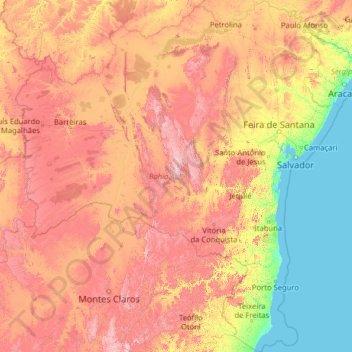
Name: Bahia topographic map, elevation, terrain.
Location: Bahia, Northeast Region, Brazil (-18.39345 -46.57728 -8.53229 -37.17715)
Average elevation: 475 m
Minimum elevation: 0 m
Maximum elevation: 1,878 m
Other topographic maps
Click on a map to view its topography, its elevation and its terrain.
São Paulo
Brazil > São Paulo > Região Metropolitana de São Paulo > São Paulo
São Paulo is in Southeastern Brazil, in southeastern São Paulo State, approximately halfway between Curitiba and Rio de Janeiro. The city is on a plateau placed beyond the Serra do Mar (Portuguese for "Sea Range" or "Coastal Range"), itself a component of the vast region known as the Brazilian Highlands,…
Average elevation: 785 m
Brasília
The city sits at an elevation of 1,000 metres (3,300 ft) and more, high on the Brazilian Highlands in the country's center-western region. Paranoá Lake, a large artificial lake, was built to increase the amount of water available and to maintain the region's humidity. It has a marina, and hosts wakeboarders…
Average elevation: 1,084 m
Ilha da Queimada Grande
Located approximately 33 kilometres (21 mi) off the coast of the state of São Paulo, Brazil, the island of Queimada Grande is approximately 430,000 square metres (106 acres) in area and ranges in elevation from 0 to 206 metres (676 ft) above sea level. It has a temperate climate that is similar to that of its…
Average elevation: 3 m
Amazon River
During what many archaeologists called the formative stage, Amazonian societies were deeply involved in the emergence of South America's highland agrarian systems. The trade with Andean civilizations in the terrains of the headwaters in the Andes formed an essential contribution to the social and religious…
Average elevation: 0 m
Pico da Bandeira
Brazil > Espírito Santo > Ibitirama
Pico da Bandeira, or Bandeira Peak (Portuguese for Flag Peak, pronounced [ˈpiku dɐ bɐ̃ˈdejɾɐ]), is the third highest mountain in Brazil, situated on the border of Espírito Santo and Minas Gerais states. It is the highest point in both states. It was considered the highest mountain in Brazil until 1965,…
Average elevation: 2,487 m
Amazon River
Brazil > Amazonas > Itacoatiara
During what many archaeologists called the formative stage, Amazonian societies were deeply involved in the emergence of South America's highland agrarian systems. The trade with Andean civilizations in the terrains of the headwaters in the Andes formed an essential contribution to the social and religious…
Average elevation: 11 m
Ilha Sumítica
Brazil > São Paulo > Região Metropolitana do Vale do Paraíba e Litoral Norte > Ilhabela
Average elevation: 1 m
Porto Alegre
Brazil > Rio Grande do Sul > Metropolitan Region of Porto Alegre > Porto Alegre
Porto Alegre has a long coastline on the Guaíba Lake, and its topography is punctuated by 40 hills. In the lake, a vast body of water, a maze of islands facing the city creates an archipelago where a unique ecosystem gives shelter to abundant wildlife. The city area concentrates 28% of the native flora of Rio…
Average elevation: 27 m
Pico da Neblina
Brazil > Amazonas > Santa Isabel do Rio Negro
For 39 years, based on an uncontested measurement performed in 1965 by topographer José Ambrósio de Miranda Pombo, using a theodolite, the elevation of Pico da Neblina was thought to be 3,014 metres (9,888 ft), but a much more accurate measurement performed in 2004 with state-of-the-art GPS equipment by…
Average elevation: 2,178 m
Amazon River
During what many archaeologists called the formative stage, Amazonian societies were deeply involved in the emergence of South America's highland agrarian systems. The trade with Andean civilizations in the terrains of the headwaters in the Andes formed an essential contribution to the social and religious…
Average elevation: 0 m
Campina Grande
Brazil > Paraíba > Região Metropolitana de Campina Grande > Campina Grande
Average elevation: 498 m
Serra da Mantiqueira
Brazil > Minas Gerais > Passa Quatro
The Serra da Mantiqueira is a part of the Atlantic Forest ecosystem. Despite the clearing of the land for livestock raising, the difficult access to many areas has made possible for sanctuaries of well-preserved forest to still exist, with trees such as the jacarandá, Spanish cedar, canjerana, guatambu, ipê,…
Average elevation: 2,271 m
Sugarloaf
Brazil > Rio de Janeiro > Região Metropolitana do Rio de Janeiro > Rio de Janeiro
Average elevation: 17 m
Curitiba
Brazil > Paraná > Região Metropolitana de Curitiba
The city covers 432.17 km2 (166.86 sq mi) on the First Plateau of Paraná. Curitiba has a topography of smooth, rounded hills, giving it a relatively regular shape. The city has an average altitude of 934.6 m (3,066 ft) above sea level. The highest point is to the north at 1,021 m (3,350 ft), and with lower…
Average elevation: 931 m
Amazon River
During what many archaeologists called the formative stage, Amazonian societies were deeply involved in the emergence of South America's highland agrarian systems. The trade with Andean civilizations in the terrains of the headwaters in the Andes formed an essential contribution to the social and religious…
Average elevation: 19 m
Bambuí
Brazil > Minas Gerais > Bambuí > Bambuí
The city center of Bambuí is located at an elevation of 706 meters on a plateau and straddles the 20th parallel. Neighboring municipalities are: Tapiraí and Córrego Danta (N), Luz (NE), Iguatama (E), Doresópolis (SE), Piumhi (S), São Roque de Minas and Medeiros (W).
Average elevation: 708 m
Amazon River
During what many archaeologists called the formative stage, Amazonian societies were deeply involved in the emergence of South America's highland agrarian systems. The trade with Andean civilizations in the terrains of the headwaters in the Andes formed an essential contribution to the social and religious…
Average elevation: 4 m
Wei-Assipu-tepui
Wei-Assipu-tepui has a maximum elevation of around 2,400 metres (7,870 ft). Its summit plateau is highly dissected and generally inclined south-southwest (towards the Brazilian side). The rocky summit is partially forested, with flowering plants of the genus Bonnetia featuring prominently. It also hosts a…
Average elevation: 1,760 m
Chapada Diamantina
The Chapada Diamantina lies at the center of Bahia State and forms the northern part of the Espinhaço Mountain Range. The region is approximately 38,000 km2 (15,000 sq mi) in area and encompasses 58 municipalities. Technically, this region is considered a part of the caatinga biome, and contains some of its…
Average elevation: 1,390 m
Praia do Forte
Brazil > Bahia > Região Metropolitana de Salvador > Mata de São João
Average elevation: 5 m
Brasília
Brazil > Federal District > Região Integrada de Desenvolvimento do Distrito Federal e Entorno
The city sits at an elevation of 1,000 metres (3,300 ft) and more, high on the Brazilian Highlands in the country's center-western region. Paranoá Lake, a large artificial lake, was built to increase the amount of water available and to maintain the region's humidity. It has a marina, and hosts wakeboarders…
Average elevation: 1,084 m
Ilha Sumítica
Brazil > São Paulo > Região Metropolitana do Vale do Paraíba e Litoral Norte > Ilhabela
Average elevation: 1 m
Pedra do Baú
Brazil > São Paulo > Região Metropolitana do Vale do Paraíba e Litoral Norte > São Bento do Sapucaí
At its highest point, the elevation is 1,950 metres (6,400 ft).
Average elevation: 1,502 m
Amazon River
During what many archaeologists called the formative stage, Amazonian societies were deeply involved in the emergence of South America's highland agrarian systems. The trade with Andean civilizations in the terrains of the headwaters in the Andes formed an essential contribution to the social and religious…
Average elevation: 10 m
Corcovado
Brazil > Rio de Janeiro > Região Metropolitana do Rio de Janeiro > Rio de Janeiro
Average elevation: 221 m
Curitiba
Brazil > Paraná > Região Metropolitana de Curitiba
The city covers 432.17 km2 (166.86 sq mi) on the First Plateau of Paraná. Curitiba has a topography of smooth, rounded hills, giving it a relatively regular shape. The city has an average altitude of 934.6 m (3,066 ft) above sea level. The highest point is to the north at 1,021 m (3,350 ft), and with lower…
Average elevation: 931 m
Belo Horizonte
Brazil > Minas Gerais > Região Metropolitana de Belo Horizonte
In 1893, due to the climatic and topographic conditions, Curral Del Rey was selected by Minas Gerais governor Afonso Pena among other cities as the location for the new economic and cultural center of the state, under the new name of Cidade de Minas, or City of Minas.
Average elevation: 904 m
Itaipu Dam
Brazil > Paraná > Foz do Iguaçu
325 metres (1,066 ft), entire dam including the 100 metres (330 ft) high Power Line 4 Pylons atop the Barrage 260 metres (850 ft), dam + the foundation inside water until the river floor 247 metres (810 ft), 196 metres (643 ft) high of roof reinforcement concrete dam + Cranes atop the Barrage 225 metres (738…
Average elevation: 192 m
Lagoa dos Ingleses
Brazil > Minas Gerais > Região Metropolitana de Belo Horizonte > Nova Lima
Average elevation: 1,335 m
Praça Tenente Roberto Osaki
Brazil > São Paulo > Região Metropolitana de São Paulo > Osasco
Average elevation: 731 m
Amazon River
Brazil > Amazonas > Careiro da Várzea
During what many archaeologists called the formative stage, Amazonian societies were deeply involved in the emergence of South America's highland agrarian systems. The trade with Andean civilizations in the terrains of the headwaters in the Andes formed an essential contribution to the social and religious…
Average elevation: 21 m
Pico da Neblina
Brazil > Amazonas > Santa Isabel do Rio Negro
For 39 years, based on an uncontested measurement performed in 1965 by topographer José Ambrósio de Miranda Pombo, using a theodolite, the elevation of Pico da Neblina was thought to be 3,014 metres (9,888 ft), but a much more accurate measurement performed in 2004 with state-of-the-art GPS equipment by…
Average elevation: 2,178 m
Amazon River
During what many archaeologists called the formative stage, Amazonian societies were deeply involved in the emergence of South America's highland agrarian systems. The trade with Andean civilizations in the terrains of the headwaters in the Andes formed an essential contribution to the social and religious…
Average elevation: 9 m
Curitiba
Brazil > Paraná > Região Metropolitana de Curitiba
The city covers 432.17 km2 (166.86 sq mi) on the First Plateau of Paraná. Curitiba has a topography of smooth, rounded hills, giving it a relatively regular shape. The city has an average altitude of 934.6 m (3,066 ft) above sea level. The highest point is to the north at 1,021 m (3,350 ft), and with lower…
Average elevation: 931 m
Serra da Borborema
Brazil > Paraíba > Região Metropolitana de Patos > Cacimbas
Average elevation: 573 m