
Jaffrey topographic map
Interactive map
Click on the map to display elevation.
Jaffrey
Thorndike Pond is in the north, and Contoocook Lake is on the southern boundary. Mount Monadnock, elevation 3,165 feet (965 m) and the highest point in Jaffrey as well as Cheshire County, is in the northwest. Jaffrey lies mostly within the Merrimack River watershed, via the Contoocook River in the eastern part of the town, with the northwest corner of town lying in the Ashuelot River watershed, part of the larger Connecticut River watershed.
About this map
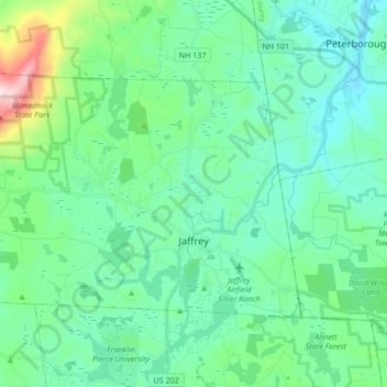
Name: Jaffrey topographic map, elevation, terrain.
Average elevation: 351 m
Minimum elevation: 216 m
Maximum elevation: 940 m
Other topographic maps
Click on a map to view its topography, its elevation and its terrain.
Camp Notre Dame
United States > New Hampshire > Cheshire County > Chesterfield
Average elevation: 223 m
Gilboa Mountain
United States > New Hampshire > Cheshire County > Westmoreland
Average elevation: 331 m
Mount Monadnock
United States > New Hampshire > Cheshire County > Jaffrey
From the base to the summit, floral species diminish with increasingly shallow soil levels. The summit is home to many different specialized sub-alpine species which can retain moisture for long periods of time. Alpine and sub-alpine species include mountain ash, cotton grass, sheep laurel, mountain sandwort,…
Average elevation: 687 m
West Chesterfield
United States > New Hampshire > Cheshire County > Chesterfield
Average elevation: 168 m