
Primorsky Krai topographic map
Interactive map
Click on the map to display elevation.
Primorsky Krai
Highlands dominate the territory of the krai. Most of the territory is mountainous, and almost 80% of it is forested. The average elevation is about 500 meters (1,600 ft). Sikhote-Alin is a mountainous formation, extending for the most part of the Krai. It consists of a number of parallel ranges: the Partizansky (Partisan), the Siny (Blue), the Kholodny (Cold), and others. There are many karst caves in the South of Primorye. The relatively accessible Spyashchaya Krasavitsa cave (the Sleeping Beauty) in the Ussuriysky Nature Preserve could be recommended for tourists. There are comparatively well-preserved fragments of the ancient volcanoes in the area.
About this map
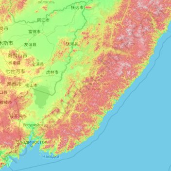
Name: Primorsky Krai topographic map, elevation, terrain.
Location: Primorsky Krai, Far Eastern Federal District, Russia (42.12271 130.39465 48.46524 139.30939)
Average elevation: 237 m
Minimum elevation: -2 m
Maximum elevation: 1,725 m
Other topographic maps
Click on a map to view its topography, its elevation and its terrain.
Sochi
Russia > Krasnodar Krai > Resort Town of Sochi (municipal formation)
Sochi has a humid subtropical climate (Köppen climate classification Cfa), at the lower elevations. Its average annual temperature is 18.9 °C (66.0 °F) during the day and 11.5 °C (52.7 °F) at night. In the coldest months—January and February—the average temperature is about 10 °C (50 °F) during the…
Average elevation: 148 m
Большая Тонга
Russia > Sverdlovsk Oblast > Североуральский муниципальный округ
Average elevation: 294 m
Ural Mountains
Russia > Khanty-Mansiysk Autonomous Okrug – Ugra > Beryozovsky District
The Ural Mountains (/ˈjʊərəl/ YOOR-əl; Russian: Ура́льские го́ры, tr. Uralskiye gory, IPA: [ʊˈralʲskʲɪjə ˈɡorɨ]; Bashkir: Урал тауҙары) or simply the Urals, are a mountain range in Eurasia that runs north-south mostly through Russia, from the coast of the Arctic Ocean to…
Average elevation: 1,435 m
Dyatlov Pine gorge
Russia > Sverdlovsk Oblast > Ивдельский муниципальный округ
Diaries and cameras found around their last campsite made it possible to track the group's route up to the day preceding the incident. On January 31, the group arrived at the edge of a highland area and began to prepare for climbing. In a wooded valley, they cached surplus food and equipment that would be used…
Average elevation: 742 m
Siberia
Russia > Krasnoyarsk Krai > Boguchansky Rayon
Eastern and central Sakha comprises numerous north–south mountain ranges of various ages. These mountains extend up to almost 3,000 metres (9,800 ft), but above a few hundred metres they are almost completely devoid of vegetation. The Verkhoyansk Range was extensively glaciated in the Pleistocene, but the…
Average elevation: 346 m
Chemashi
Russia > Khanty-Mansiysk Autonomous Okrug – Ugra > Oktyabrsky District
Average elevation: 25 m
Шайтанка
Russia > Khanty-Mansiysk Autonomous Okrug – Ugra > Beryozovsky District > Beryozovo
Average elevation: 24 m
Сосновка
Russia > Khanty-Mansiysk Autonomous Okrug – Ugra > Beloyarsky District
Average elevation: 100 m
Верхнеказымский
Russia > Khanty-Mansiysk Autonomous Okrug – Ugra > Beloyarsky District
Average elevation: 40 m
Охтеурье
Russia > Khanty-Mansiysk Autonomous Okrug – Ugra > Nizhnevartovsky District
Average elevation: 51 m
Таван-Богдо-Ула / Таван богд / 奎屯峰
Russia > Altai Republic > Kosh-Agachsky Rayon
Average elevation: 3,775 m
Nikol'skiy Pogost
Russia > Arkhangelsk Oblast > Шенкурский муниципальный округ
Average elevation: 41 m