
Meghalaya topographic map
Interactive map
Click on the map to display elevation.
Meghalaya
Meghalaya, alongside neighbouring Indian states, has been of archaeological interest. People have lived in Meghalaya since the Neolithic period. Neolithic sites discovered so far are located in areas of high elevation in Khasi Hills, Garo Hills and in neighbouring states, where Neolithic style jhum or shifting cultivation is practiced even today. The highland plateaus fed by abundant rains provided safety from floods and a rich soil. The importance of Meghalaya is its possible role in human history via domestication of rice. One of the competing theories for the origin of rice comes from Ian Glover, who states, "India is the center of greatest diversity of domesticated rice with over 20,000 identified species and Northeast India is the most favorable single area of the origin of domesticated rice." The limited archaeology done in the hills of Meghalaya suggest human settlement since ancient times.
About this map
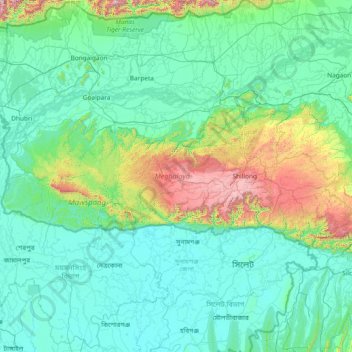
Name: Meghalaya topographic map, elevation, terrain.
Location: Meghalaya, India (25.03065 89.81444 26.11817 92.80274)
Average elevation: 244 m
Minimum elevation: 0 m
Maximum elevation: 2,336 m
Other topographic maps
Click on a map to view its topography, its elevation and its terrain.
Dankuni
India > West Bengal > Chanditala - II
Located at an elevation of None meters (0 feet) above sea level, city's yearly temperature is 30.28 °C (86.5 °F) and it is 4.31% higher than India's averages. Dankuni typically receives about 150.21 millimeters (5.91 inches) of precipitation and has 150.54 rainy days (41.24% of the time) annually.
Average elevation: 6 m
Chennai
Chennai is located on the south–eastern coast of India in the north–eastern part of Tamil Nadu on a flat coastal plain known as the Eastern Coastal Plains. Its average elevation is around 6.7 metres (22 ft), and its highest point is 60 m (200 ft). Chennai is 2,184 kilometres (1,357 mi) south of Delhi,…
Average elevation: 7 m
Visakhapatnam
India > Andhra Pradesh > Visakhapatnam (Urban)
The city is situated between the Eastern Ghats and the Bay of Bengal. The city coordinates lies between 17.7041 N and 83.2977 E. The city's area is 682 km2. The average elevation is 45 metres. Visakhpatnam is situated in Coastal Andhra Region.
Average elevation: 35 m
Vadodara
India > Gujarat > Vadodara Rural Taluka
Vadodara is located at 22°18′N 73°11′E / 22.30°N 73.19°E / 22.30; 73.19 in western India at an elevation of 39 metres (128 ft). It is the tenth-largest city in India with an area of 400 square kilometres (150 sq mi) and a population of 3.5 million, according to the 2010–11 census. The city…
Average elevation: 36 m
Rupnagar
India > Punjab > Rupnagar Tahsil
Rupnagar is located at 30°58′N 76°32′E / 30.97°N 76.53°E / 30.97; 76.53. It has an average elevation of 260 metres (850 ft). The town lies on the bank of Satluj River and the Shivalik hill range spreads along the opposite bank of the river.
Average elevation: 281 m
Narnaul
Narnaul is located at 28°02′N 76°07′E / 28.04°N 76.11°E / 28.04; 76.11. It has an average elevation of 300 meters (977 feet). The district is rich in mineral resources such as iron ore, copper ore, beryl, tourmaline, muscovite, biotite, albite, calcite, and quartz.
Average elevation: 318 m
Thiruvilliputtur state assembly constituency
India > Tamil Nadu > Srivilliputhur
Average elevation: 321 m
Indrasan
India > Himachal Pradesh > Lahul
Mount Indrasan is located at an altitude of 6221 metres above sea level in Kullu district, Himachal Pradesh. Mt. Indrasan is considered as the most difficult mountain to climb in the Pir Panjal range of the Himalayas because of the challenges involved in scaling it. It was first climbed on October 13, 1962, by…
Average elevation: 5,374 m
Ujjain
India > Madhya Pradesh > Ujjain NagarTahsil
Ujjain is located in the west-central part of India, and is north of the upper limit of the Vindhya mountain ranges. Located on the Malwa plateau, it is higher than the north Indian plains and the land rises towards the Vindhya Range to the south. Ujjain's coordinates are 23°10′N 75°46′E /…
Average elevation: 501 m
Laksar
India > Uttarakhand > Laksar
Laksar has an average elevation of 227 metres (745 feet). It is situated between the towns of Khanpur and Sultanpur, and close to the towns of Pathri, Jhabrera and Roorkee in Haridwar district.
Average elevation: 238 m
Amarnath Cave Temple
India > Jammu and Kashmir > Pahalgam
Amarnath Temple is a Hindu shrine located in the Pahalgam tehsil of the Anantnag district of Jammu and Kashmir, India. It is a cave situated at an altitude of 3,888 m (12,756 ft), about 168 km from Anantnag city, the district headquarters, 141 km (88 mi) from Srinagar, the summer capital of Jammu and Kashmir,…
Average elevation: 4,325 m
Mysuru
India > Karnataka > Mysuru taluk
Mysore (/maɪˈsɔːr/ (listen)), officially Mysuru ([ˈmaɪˈsuːɾu] (listen)), is a city in the southern part of the state of Karnataka, India. Mysore city is geographically located between 12° 18′ 26″ north latitude and 76° 38′ 59″ east longitude. It is located at an altitude of 770 m (2,530 ft)…
Average elevation: 727 m
Thiruvananthapuram
India > Kerala > Thiruvananthapuram
Thiruvananthapuram is built on seven hills by the seashore and is at 8°30′N 76°54′E / 8.5°N 76.9°E / 8.5; 76.9 on the west coast, near the southern tip of mainland India. The city is on the west coast of India and is bounded by the Laccadive Sea to its west and the Western Ghats to its east.…
Average elevation: 33 m
Indore
India > Madhya Pradesh > Juni Indore Tahsil
Indore /ɪnˈdɔːr/ (listen) is the most populous and the largest city in the Indian state of Madhya Pradesh. It serves as the headquarters of both Indore District and Indore Division. It is also considered as an education hub of the state and has campuses of both the Indian Institute of Technology and the…
Average elevation: 555 m
Guwahati
Professor Abani Kumar Bhagawati of Gauhati University stated that since before there were sufficient wetlands to absorb rainwater and channels to carry excess water to the Brahmaputra, the city did not experience floods. However, human interference has disrupted the natural topography, leading to the current…
Average elevation: 113 m
Jamshedpur
India > Jharkhand > Golmuri-Cum-Jugsalai
Jamshedpur is situated at the southern end of the state of Jharkhand and is bordered by the states of Odisha and West Bengal. The average elevation of the city is 135 metres while the range is from 129 m to 151 m. Total geographical area of Jamshedpur is 224 km square. Jamshedpur is primarily located in a…
Average elevation: 195 m
Khandwa
India > Madhya Pradesh > Khandwa Nagar Tahsil
Khandwa is located at 21°50′N 76°20′E / 21.83°N 76.33°E / 21.83; 76.33. It has an average elevation of 313 metres (1026 feet).
Average elevation: 325 m
Kadiri
India > Andhra Pradesh > Kadiri
Kadiri is located at 78.170 degrees E longitude and 14.120 degrees N latitude and has an average elevation of 504.00 meters (1653 feet) above MSL. Kadiri is surrounded by hill on the north and east.
Average elevation: 550 m
Leh
Leh (/ˈlɛ/) (Ladakhi: གླེ) is the joint capital and largest city of Ladakh, a union territory of India. Leh, located in the Leh district, was also the historical capital of the Kingdom of Ladakh, the seat of which was in the Leh Palace, the former residence of the royal family of Ladakh, built in the…
Average elevation: 3,653 m
Lucknow
India > Uttar Pradesh > Lucknow
Lucknow stands at an elevation of approximately 123 metres (404 ft) above sea level. The city had an area of 402 km2 (155 square miles) until December 2019, when 88 villages were added to the municipal limits and the area increased to 631 km2 (244 square miles). Bounded on the east by Barabanki, on the west by…
Average elevation: 120 m