
Make a donation
Gear up for your next adventure:
As an Amazon Associate, this site earns from qualifying purchases at no extra cost to you.
Morobe topographic map
Click on the map to display elevation.
Make a donation
Gear up for your next adventure:
As an Amazon Associate, this site earns from qualifying purchases at no extra cost to you.
About this map
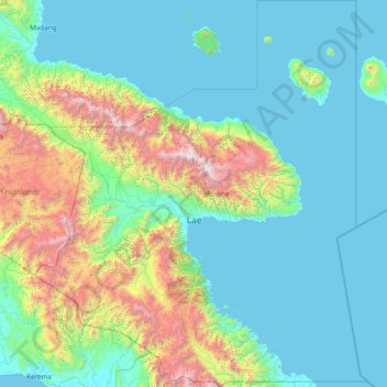
Name: Morobe topographic map, elevation, terrain.
Location: Morobe, Momase Region, Papua New Guinea (-8.04167 145.71291 -5.00000 148.37819)
Average elevation: 580 m
Minimum elevation: -1 m
Maximum elevation: 4,030 m
Make a donation
Gear up for your next adventure:
As an Amazon Associate, this site earns from qualifying purchases at no extra cost to you.
Other topographic maps
Click on a map to view its topography, its elevation and its terrain.
Port Moresby
Papua New Guinea > National Capital District > National Capital District
Average elevation: 34 m
Kainantu
Papua New Guinea > Eastern Highlands > Kainantu
A narrow south-east-trending dissected plateau dominates area to the south; it forms the watershed between rivers draining north to the Markham-Ramu Graben, and those draining south to the Papuan coast. The plateau ranges in elevation between 7,500 feet (2,300 m) and 8,000 feet (2,400 m) above sea level, and…
Average elevation: 1,628 m
Make a donation
Gear up for your next adventure:
As an Amazon Associate, this site earns from qualifying purchases at no extra cost to you.
Make a donation
Gear up for your next adventure:
As an Amazon Associate, this site earns from qualifying purchases at no extra cost to you.
Port Moresby
Papua New Guinea > National Capital District > National Capital District
Average elevation: 34 m
Make a donation
Gear up for your next adventure:
As an Amazon Associate, this site earns from qualifying purchases at no extra cost to you.
Port Moresby
Papua New Guinea > National Capital District > National Capital District
Average elevation: 34 m
Make a donation
Gear up for your next adventure:
As an Amazon Associate, this site earns from qualifying purchases at no extra cost to you.
Make a donation
Gear up for your next adventure:
As an Amazon Associate, this site earns from qualifying purchases at no extra cost to you.
Goroka
Papua New Guinea > Eastern Highlands > Goroka District
Goroka has a subtropical highland climate (Cfb). Due to altitude Goroka features warm to very warm afternoons and cool to mild mornings year-round, with heavy rainfall most of the year and low rainfall from June to September.
Average elevation: 1,890 m
Make a donation
Gear up for your next adventure:
As an Amazon Associate, this site earns from qualifying purchases at no extra cost to you.
Kainantu
Papua New Guinea > Eastern Highlands
A narrow south-east-trending dissected plateau dominates area to the south; it forms the watershed between rivers draining north to the Markham-Ramu Graben, and those draining south to the Papuan coast. The plateau ranges in elevation between 7,500 feet (2,300 m) and 8,000 feet (2,400 m) above sea level, and…
Average elevation: 1,628 m
Make a donation
Gear up for your next adventure:
As an Amazon Associate, this site earns from qualifying purchases at no extra cost to you.
Port Moresby
Papua New Guinea > National Capital District > National Capital District
Average elevation: 34 m
Make a donation
Gear up for your next adventure:
As an Amazon Associate, this site earns from qualifying purchases at no extra cost to you.
Make a donation
Gear up for your next adventure:
As an Amazon Associate, this site earns from qualifying purchases at no extra cost to you.
Make a donation
Gear up for your next adventure:
As an Amazon Associate, this site earns from qualifying purchases at no extra cost to you.
Make a donation
Gear up for your next adventure:
As an Amazon Associate, this site earns from qualifying purchases at no extra cost to you.
Make a donation
Gear up for your next adventure:
As an Amazon Associate, this site earns from qualifying purchases at no extra cost to you.
Make a donation
Gear up for your next adventure:
As an Amazon Associate, this site earns from qualifying purchases at no extra cost to you.
Make a donation
Gear up for your next adventure:
As an Amazon Associate, this site earns from qualifying purchases at no extra cost to you.
Make a donation
Gear up for your next adventure:
As an Amazon Associate, this site earns from qualifying purchases at no extra cost to you.
Make a donation
Gear up for your next adventure:
As an Amazon Associate, this site earns from qualifying purchases at no extra cost to you.
Goroka
Papua New Guinea > Eastern Highlands > Goroka District
Goroka has a subtropical highland climate (Cfb). Due to altitude Goroka features warm to very warm afternoons and cool to mild mornings year-round, with heavy rainfall most of the year and low rainfall from June to September.
Average elevation: 1,890 m
Kundiawa
Kundiawa has a relatively cool tropical rainforest climate (Köppen Af), bordering on a subtropical highland climate (Cfb) due to altitude. It features mild mornings, very warm but not hot afternoons, and heavy rainfall year round.
Average elevation: 2,077 m
Make a donation
Gear up for your next adventure:
As an Amazon Associate, this site earns from qualifying purchases at no extra cost to you.
Make a donation
Gear up for your next adventure:
As an Amazon Associate, this site earns from qualifying purchases at no extra cost to you.
Make a donation
Gear up for your next adventure:
As an Amazon Associate, this site earns from qualifying purchases at no extra cost to you.
Make a donation
Gear up for your next adventure:
As an Amazon Associate, this site earns from qualifying purchases at no extra cost to you.
Make a donation
Gear up for your next adventure:
As an Amazon Associate, this site earns from qualifying purchases at no extra cost to you.
Make a donation
Gear up for your next adventure:
As an Amazon Associate, this site earns from qualifying purchases at no extra cost to you.
Laloki River
Papua New Guinea > National Capital District > National Capital District > Port Moresby
Average elevation: 38 m
Make a donation
Gear up for your next adventure:
As an Amazon Associate, this site earns from qualifying purchases at no extra cost to you.
Make a donation
Gear up for your next adventure:
As an Amazon Associate, this site earns from qualifying purchases at no extra cost to you.