
Victoria Park topographic map
Interactive map
Click on the map to display elevation.
About this map
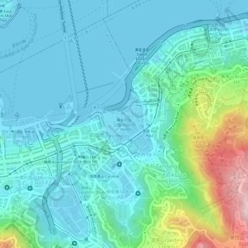
Name: Victoria Park topographic map, elevation, terrain.
Average elevation: 64 m
Minimum elevation: 0 m
Maximum elevation: 311 m
Other topographic maps
Click on a map to view its topography, its elevation and its terrain.
Braemar Hill
China > Hong Kong > Hong Kong Island
Braemar Hill, Hong Kong Island, Hong Kong, 000000, China
Average elevation: 89 m
Pok Fu Lam Reservoir
China > Hong Kong > Hong Kong Island
Pok Fu Lam Reservoir, Telegraph Bay, Pok Fu Lam, Southern District, Hong Kong Island, Hong Kong, China
Average elevation: 192 m
Victoria Peak
China > Hong Kong > Hong Kong Island
Victoria Peak, Hong Kong Island, Hong Kong, China
Average elevation: 209 m
Tai Tam Mound Waterfall
China > Hong Kong > Hong Kong Island
Tai Tam Mound Waterfall, Southern District, Hong Kong Island, Hong Kong, China
Average elevation: 150 m
Wong Chuk Hang San Wai
China > Hong Kong > Hong Kong Island > Wong Chuk Hang San Wai
Wong Chuk Hang San Wai, Southern District, Hong Kong Island, Hong Kong, China
Average elevation: 116 m
Sai Wan
China > Hong Kong > Hong Kong Island
Sai Wan, Central and Western District, Hong Kong Island, Hong Kong, China
Average elevation: 81 m
Southern District
China > Hong Kong > Hong Kong Island
Southern District, Hong Kong Island, Hong Kong, China
Average elevation: 36 m