
Mindoro topographic map
Interactive map
Click on the map to display elevation.
About this map
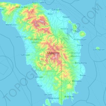
Name: Mindoro topographic map, elevation, terrain.
Location: Mindoro, Occidental Mindoro, Mimaropa, Philippines (12.20770 120.29872 13.53087 121.55861)
Average elevation: 173 m
Minimum elevation: -2 m
Maximum elevation: 2,532 m
Mindoro is the seventh largest and eighth-most populous island in the Philippines. With a total land area of 10,571 km2 ( 4,082 sq.mi ) and has a population of 1,408,454 as of 2020 census. It is located off the southwestern coast of Luzon and northeast of Palawan. Mindoro is divided into two provinces: Occidental Mindoro and Oriental Mindoro. San Jose is the largest settlement on the island with a total population of 143,430 inhabitants as of 2015. The southern coast of Mindoro forms the northeastern extremum of the Sulu Sea. Mount Halcon is the highest point on the island, standing at 8,484 feet (2,586 m) above sea level located in Oriental Mindoro. Mount Baco is the island's second highest mountain with an elevation of 8,163 feet (2,488 m), located in the province of Occidental Mindoro.
Other topographic maps
Click on a map to view its topography, its elevation and its terrain.
Sablayan
Philippines > Occidental Mindoro
Sablayan, Occidental Mindoro, Mimaropa, 5104, Philippines
Average elevation: 239 m
Abra de Ilog
Philippines > Occidental Mindoro > Abra de Ilog
Abra de Ilog, Occidental Mindoro, Mimaropa, Philippines
Average elevation: 322 m
Lumang Bayan
Philippines > Occidental Mindoro > Abra de Ilog
Lumang Bayan, Abra de Ilog, Occidental Mindoro, Mimaropa, Philippines
Average elevation: 218 m
San Jose
Philippines > Occidental Mindoro > San Jose
San Jose, Occidental Mindoro, Mimaropa, 5100, Philippines
Average elevation: 81 m
Magsaysay
Philippines > Occidental Mindoro > Magsaysay
Magsaysay, Occidental Mindoro, Mimaropa, Philippines
Average elevation: 8 m
Mamburao
Philippines > Occidental Mindoro
Mamburao, Occidental Mindoro, Mimaropa, Philippines
Average elevation: 108 m
Santa Cruz
Philippines > Occidental Mindoro
Santa Cruz, Occidental Mindoro, Mimaropa, Philippines
Average elevation: 193 m
Paluan
Philippines > Occidental Mindoro > Paluan
Paluan, Occidental Mindoro, Mimaropa, Philippines
Average elevation: 111 m
Lubang
Philippines > Occidental Mindoro > Lubang
Lubang, Occidental Mindoro, Mimaropa, Philippines
Average elevation: 12 m
Looc
Philippines > Occidental Mindoro > Looc
Looc, Occidental Mindoro, Mimaropa, 5111, Philippines
Average elevation: 10 m