
Haddonfield topographic map
Interactive map
Click on the map to display elevation.
About this map
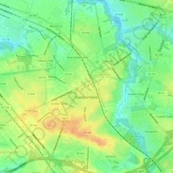
Name: Haddonfield topographic map, elevation, terrain.
Location: Haddonfield, Camden County, New Jersey, 08033, United States (39.87192 -75.05147 39.91652 -75.01632)
Average elevation: 18 m
Minimum elevation: 1 m
Maximum elevation: 37 m
Other topographic maps
Click on a map to view its topography, its elevation and its terrain.
Andrews
United States > New Jersey > Camden County > Winslow Township > Sicklerville
Average elevation: 40 m
Cherry Valley
United States > New Jersey > Camden County > Cherry Hill Township > Cherry Valley
Average elevation: 16 m
Haddon Towne
United States > New Jersey > Camden County > Cherry Hill Township
Average elevation: 20 m