
Make a donation
Gear up for your next adventure:
As an Amazon Associate, this site earns from qualifying purchases at no extra cost to you.
Plainsboro Township topographic map
Click on the map to display elevation.
Gear up for your next adventure:
As an Amazon Associate, this site earns from qualifying purchases at no extra cost to you.
About this map
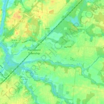
Name: Plainsboro Township topographic map, elevation, terrain.
Average elevation: 28 m
Minimum elevation: 13 m
Maximum elevation: 53 m
Make a donation
Gear up for your next adventure:
As an Amazon Associate, this site earns from qualifying purchases at no extra cost to you.
Other topographic maps
Click on a map to view its topography, its elevation and its terrain.
Possumtown
United States > New Jersey > Middlesex County > Piscataway Township
Average elevation: 19 m
Make a donation
Gear up for your next adventure:
As an Amazon Associate, this site earns from qualifying purchases at no extra cost to you.
Elmer B Boyd Park
United States > New Jersey > Middlesex County > New Brunswick > Feaster Park
Average elevation: 22 m
Make a donation
Gear up for your next adventure:
As an Amazon Associate, this site earns from qualifying purchases at no extra cost to you.
Fieldville
United States > New Jersey > Middlesex County > Piscataway Township
Average elevation: 17 m
Middlesex Downs
United States > New Jersey > Middlesex County > Monroe Township
Average elevation: 33 m
Make a donation
Gear up for your next adventure:
As an Amazon Associate, this site earns from qualifying purchases at no extra cost to you.
Sand Hills
United States > New Jersey > Middlesex County > Woodbridge Township > Fords
Average elevation: 24 m
Make a donation
Gear up for your next adventure:
As an Amazon Associate, this site earns from qualifying purchases at no extra cost to you.
Woodbridge
United States > New Jersey > Middlesex County > Woodbridge Township
Average elevation: 16 m
Make a donation
Gear up for your next adventure:
As an Amazon Associate, this site earns from qualifying purchases at no extra cost to you.
Prospect Plains
United States > New Jersey > Middlesex County > Monroe Township
Average elevation: 39 m
North Stelton
United States > New Jersey > Middlesex County > Piscataway Township
Average elevation: 29 m
Make a donation
Gear up for your next adventure:
As an Amazon Associate, this site earns from qualifying purchases at no extra cost to you.
Berdines Corners
United States > New Jersey > Middlesex County > North Brunswick
Average elevation: 29 m
Make a donation
Gear up for your next adventure:
As an Amazon Associate, this site earns from qualifying purchases at no extra cost to you.
Lynn Woodoaks
United States > New Jersey > Middlesex County > Woodbridge Township > Colonia
Average elevation: 31 m
Make a donation
Gear up for your next adventure:
As an Amazon Associate, this site earns from qualifying purchases at no extra cost to you.
Fairview Knolls
United States > New Jersey > Middlesex County > East Brunswick Township
Average elevation: 31 m
Highland Park
United States > New Jersey > Middlesex County > Highland Park > Highland Park
Average elevation: 24 m
Make a donation
Gear up for your next adventure:
As an Amazon Associate, this site earns from qualifying purchases at no extra cost to you.
New Market
United States > New Jersey > Middlesex County > Piscataway Township
Average elevation: 23 m
South River
United States > New Jersey > Middlesex County > South River > South River
Average elevation: 19 m
Make a donation
Gear up for your next adventure:
As an Amazon Associate, this site earns from qualifying purchases at no extra cost to you.