
North Brunswick topographic map
Interactive map
Click on the map to display elevation.
About this map
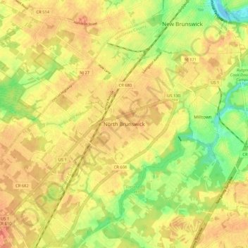
Name: North Brunswick topographic map, elevation, terrain.
Average elevation: 30 m
Minimum elevation: -3 m
Maximum elevation: 49 m
Other topographic maps
Click on a map to view its topography, its elevation and its terrain.
Elmer B Boyd Park
United States > New Jersey > Middlesex County > New Brunswick > Feaster Park
Average elevation: 22 m
Edison
United States > New Jersey > Middlesex County
While the Township's topography is mostly flat, there are some hillier areas, especially along the Perth Amboy Moraine, which forms an arc across the township, left by the southern limit of the Laurentide Ice Sheet. The highest point is on Grandview Avenue, which reaches a maximum elevation of about 220 feet.…
Average elevation: 25 m
Whittingham
United States > New Jersey > Middlesex County > Monroe Township > Half Acre
Average elevation: 45 m
Woodbridge Township
United States > New Jersey > Middlesex County
Woodbridge's geographical features make it prone to repeated flooding. It is surrounded by water on three sides: the Arthur Kill, a tidal strait to the east, and tidal rivers to the south, Raritan River, and north, Rahway River; and, much of the developed land in Woodbridge has low elevations, as little as…
Average elevation: 16 m
Edison
United States > New Jersey > Middlesex County
While the Township's topography is mostly flat, there are some hillier areas, especially along the Perth Amboy Moraine, which forms an arc across the township, left by the southern limit of the Laurentide Ice Sheet. The highest point is on Grandview Avenue, which reaches a maximum elevation of about 220 feet.…
Average elevation: 25 m
Rutgers University-Livingston Campus
United States > New Jersey > Middlesex County > Piscataway Township
Average elevation: 25 m
Rutgers Ecological Preserve
United States > New Jersey > Middlesex County > Highland Park
Average elevation: 23 m
Cranbury
United States > New Jersey > Middlesex County > Cranbury Township > Cranbury
Average elevation: 31 m
Iselin
United States > New Jersey > Middlesex County > Woodbridge Township > Iselin
Average elevation: 23 m
Whittingham
United States > New Jersey > Middlesex County > Monroe Township > Half Acre
Average elevation: 43 m
Woodbridge Township
United States > New Jersey > Middlesex County
Woodbridge's geographical features make it prone to repeated flooding. It is surrounded by water on three sides: the Arthur Kill, a tidal strait to the east, and tidal rivers to the south, Raritan River, and north, Rahway River; and, much of the developed land in Woodbridge has low elevations, as little as…
Average elevation: 16 m
Avenel
United States > New Jersey > Middlesex County > Woodbridge Township > Port Reading
Average elevation: 11 m
Woodbridge
United States > New Jersey > Middlesex County > Woodbridge Township > Woodbridge
Average elevation: 17 m
Edison
United States > New Jersey > Middlesex County
While the Township's topography is mostly flat, there are some more hilly areas in the township. The highest point is on Grandview Avenue, which reaches a maximum elevation of about 220 feet, which is the highest point in the Township. The lowest elevation in the township is on sea level on the Raritan River.
Average elevation: 25 m
Old Bridge
United States > New Jersey > Middlesex County > Old Bridge Township > Old Bridge
Average elevation: 17 m
Edison
United States > New Jersey > Middlesex County
While the Township's topography is mostly flat, there are some hillier areas, especially along the Perth Amboy Moraine, which forms an arc across the township, left by the southern limit of the Laurentide Ice Sheet. The highest point is on Grandview Avenue, which reaches a maximum elevation of about 220 feet.…
Average elevation: 25 m
Old Bridge
United States > New Jersey > Middlesex County > Old Bridge Township > Old Bridge
Average elevation: 17 m