
South Brunswick topographic map
Interactive map
Click on the map to display elevation.
About this map
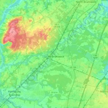
Name: South Brunswick topographic map, elevation, terrain.
Location: South Brunswick, Middlesex County, New Jersey, United States (40.32846 -74.62388 40.44138 -74.43684)
Average elevation: 36 m
Minimum elevation: 6 m
Maximum elevation: 102 m
Other topographic maps
Click on a map to view its topography, its elevation and its terrain.
Fieldville
United States > New Jersey > Middlesex County > Piscataway Township
Average elevation: 17 m
Sand Hills
United States > New Jersey > Middlesex County > Woodbridge Township > Fords
Average elevation: 24 m
Middlesex Downs
United States > New Jersey > Middlesex County > Monroe Township
Average elevation: 33 m
Woodbridge
United States > New Jersey > Middlesex County > Woodbridge Township
Average elevation: 16 m
Prospect Plains
United States > New Jersey > Middlesex County > Monroe Township
Average elevation: 39 m
Berdines Corners
United States > New Jersey > Middlesex County > North Brunswick
Average elevation: 29 m
Lynn Woodoaks
United States > New Jersey > Middlesex County > Woodbridge Township > Colonia
Average elevation: 31 m
Fairview Knolls
United States > New Jersey > Middlesex County > East Brunswick Township
Average elevation: 31 m
South River
United States > New Jersey > Middlesex County > South River > South River
Average elevation: 19 m
New Market
United States > New Jersey > Middlesex County > Piscataway Township
Average elevation: 23 m
Highland Park
United States > New Jersey > Middlesex County > Highland Park > Highland Park
Average elevation: 24 m